


|
||

|

|
|

|
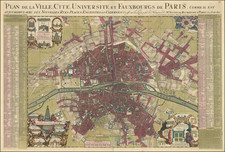
Beautiful early 18th Century map of Paris published by the highly respected mapmaker, Alexis Hubert Jaillot, the Geographer Royal to King Louis XIV.
Jaillot's plan of Paris provides a fascinating snapshot of the city's evolution during the late 17th and early 18th centuries. This era, significantly punctuated by the reign of Louis XIV and marked by the artistic and architectural prowess of several prominent figures, saw Paris transform into a symbol of grandeur and baroque magnificence. Among the major architectural additions to Paris in the prior years are:
-
Place Vendôme (1699): Originally called 'Place Louis-le-Grand', it was intended as a monument to the glory of the army of Louis XIV.
-
Hôtel des Invalides (completed in 1706): Originally initiated by Louis XIV in 1670 to provide accommodation for war veterans, the site's Eglise Saint-Louis became the burial site for Napoleon Bonaparte in the 19th century.
-
Pont Royal (1685-1689): One of the first bridges to be built without houses upon it, it replaced the wooden bridge that was there from 1632.
-
Parks and Gardens: The Jardin des Plantes was expanded and transformed into a botanical garden in the 1690s under the instruction of Louis XIV.
This plan was prepared in the final days of the reign of Louis XIV (1638-1715), known as the 'Sun King'. His reign profoundly influenced art, culture, and architecture in France. Louis XV began his reign in 1715 after the death of Louis XIV and was five years old at the time.
The period was marked by the work of a number of important architects, including
- Jules Hardouin-Mansart (1646-1708): One of the most influential architects of his time, he played a pivotal role in the development of the French Baroque architectural style. Works from this period include the Place Vendôme and parts of the Palace of Versailles.
- Robert de Cotte (1656-1735): A major figure in the latter period of this era, he was involved in many architectural projects, including some in collaboration with Mansart.
- André Le Nôtre (1613-1700): The primary landscape architect for Louis XIV, Le Nôtre's genius is most evident in the gardens of Versailles.
During this time period, Paris witnessed significant architectural, cultural, and political transformations. The city began to take a shape that would later inspire cities around the world. The artistic genius of its architects, coupled with the ambitions of its monarchs, especially Louis XIV, saw Paris burgeon into an emblem of European grandeur.
The map is based upon the map of Jouvin de Rochefort, who in the late 17th century, authored an influential map of Paris which stands as a significant contribution to the cartography of the city. The 1676 map provided the most comprehensive look at Paris during a time of substantial urban development and transformation under Louis XIV in the final decades of the 17th Century.
The map was first issued in 1714. The map can be differentiated from the a later state, issued around 1735, which includes updated features, including the Bourbon and Lassay hotels (built in 1722) and the Tuileries bridge. Also the Conference gate, which was demolished in 1730, is not shown.
Alexis-Hubert Jaillot (ca. 1632-1712) was one of the most important French cartographers of the seventeenth century. Jaillot traveled to Paris with his brother, Simon, in 1657, hoping to take advantage of Louis XIV's call to the artists and scientists of France to settle and work in Paris. Originally a sculptor, he married the daughter of Nicholas Berey, Jeanne Berey, in 1664, and went into partnership with Nicholas Sanson's sons. Beginning in 1669, he re-engraved and often enlarged many of Sanson's maps, filling in the gap left by the destruction of the Blaeu's printing establishment in 1672.
![[ Paris Wall Map ] Plan Geometral de Paris a L'Echelle de 0.001 pour 10 Metres ( 1/100,000)](https://storage.googleapis.com/raremaps/img/small/97781.jpg)
![(Parishes of Paris) Plan des Paroisses de Paris Avec la Distinction des Parties Eparses qui en Dependent Dresse par Ordre. . . [in 4 sheets]](https://storage.googleapis.com/raremaps/img/small/78579.jpg)