


|
||

|

|
|

|
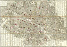
A Retrospective Wall Map of Paris Published by the Department of Historical Works of the City.
A handsome 1904 reproduction of Jean Junie's monumental plan of the parishes of Paris, first published in 1786 and here reproduced by the Department of Historical Works of the City of Paris. This later lithograph was produced by L. Wuhrer and based on the example of the map held at the French National Archives. We have been unable to trace any additional examples of the original 1786 map, and the lack of digitized examples renders the Wuhrer map of notable interest to the history of Paris.
The map is highly detailed, dividing the map by coloring by city and faubourg parish as it stood in the late 18th century. City and university parishes are given brief descriptions of their extents. An extensive indexed list of points is provided. Streets, buildings, and churches are shown.
The 1786 map was created by order of the Archbishop of Paris Antoine-Éléonor-Léon Leclerc de Juigné, who would become a representative in the Estates-General for the clergy before fleeing the country. An important figure who directed many works of charity prior to the Revolution, producing a plan of the parishes of the city would have benefitted his efforts to better understand the needs of his flock.
![[ Saint-Denis ] Pourtraict de la Ville de Sainct Denis en France](https://storage.googleapis.com/raremaps/img/small/74991.jpg)
![[Paris] Nouvelle Carte Routiere du Voyageur aux Environs de Paris Contenant: les Departemens de la Seine, de Seine et Oise et partie ceux adjacens; La Seule Ornee des Vues principaux Monumens qui s'y trouvent situes depose 1830](https://storage.googleapis.com/raremaps/img/small/62632.jpg)
![[Paris - Soissons - Champagne / area between the Seine River, Oise, River, Aisne River and Marne Rivers]](https://storage.googleapis.com/raremaps/img/small/90932.jpg)