|
||

|

|
|

|
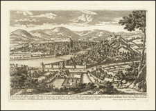
Luca, Civitas Thusciae, published by Pieter van der Aa in Leiden around 1715, offers a detailed bird's-eye view of the city of Lucca in Tuscany. It vividly portrays the city's fortifications and the encompassing moat, with buildings individually rendered in a three-dimensional perspective. Notable features are identified, including key churches, palaces, bridges, and other landmarks, providing a comprehensive depiction of the city during the early 18th century.
Lucca, a historic city in northern Tuscany, was known for its well-preserved Renaissance walls and rich architectural heritage. During the time the map was created, Lucca was a thriving independent city-state with an economy based on silk production. The fortifications, considered some of the most impressive in Europe, were a symbol of the city's autonomy and defensive prowess.
Pieter van der Aa's representation is remarkable for its attention to detail and artistic mastery. The three-dimensional rendering of buildings, the clear demarcation of fortifications, and the inclusion of specific landmarks provide a rich visual document of Lucca's urban landscape. The accompanying "Explicatio" serves as a key to the map, identifying significant sites such as S. Martino, S. Girolamo, Il Palazzo, and Ponte della Frotta, among others.
Pieter van der Aa (1659-1733) was a Dutch mapmaker and publisher who printed pirated editions of foreign bestsellers and illustrated books, but is best known for his voluminous output of maps and atlases. Van der Aa was born to a German stonecutter from Holstein. Interestingly, all three van der Aa sons came to be involved in the printing business. Hildebrand was a copper engraver and Boudewyn was a printer.
![[Ceva, Italy] Ceva. Civitas Antiqua, et Marchionatus ejusdem Nominis Caput](https://storage.googleapis.com/raremaps/img/small/89094.jpg)