This item has been sold, but you can enter your email address to be notified if another example becomes available.


|
||

|

|
|

|
Stock# 95753
Description
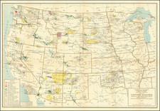
Historical map by H.C. Tunison showing the states and territories of the United States as they were in 1812, extending west to Natchitoches, with an inset map of the country circa 1776. Mobile District, formerly in West Florida, appears as part of the Mississippi Territory due to its 1812 annexation.
Condition Description
Original hand-color. Slight toning and minimal foxing, neither affecting image, contained to margins. Eastern half of U.S. map on verso.
![[ United States ] Carte Speciale, Historique et. Geographique De La Republique Des Etats-Unis De L'Amerique Du Nord](https://storage.googleapis.com/raremaps/img/small/98460.jpg)