|
||

|

|
|

|
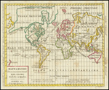
This late 16th Century decorative miniature map presents a fascinating early perspective on the world, reflecting the navigational and geographical understanding of the time. Engraved with an oval projection, it serves as an intriguing snapshot of the era's world view, especially focusing on Thomas Cavendish's sixteenth-century circumnavigation.
Aesthetically, the map is rich in ornamental features. Its world depiction is contained within a strapwork border, gracefully adorned with fine flowers. Two parrots, symbolizing exotic lands, grace the top left and right corners, adding an element of color and vibrancy to the map.
The map highlights certain geographical features and myths prevalent in the period's cartography:
- Northwest Passage: The map's depiction of a clear Northwest passage illustrates the ongoing search for a direct route from Europe to Asia through the Arctic Ocean.
- Quivira Regnum and Anian Regnum: These mythical lands in North America reflect the explorers' expectations of finding rich kingdoms and straits, symbolizing the elusive dreams of wealth and discovery.
- Terra Australis Nondum Cognita: Literally translating to "The Southern Land Not Yet Known," this term represents the imagined vast continent in the Southern Hemisphere, a common feature in maps of the time.
- Java Maior and Minor: The representation of Java Major and Minor might be influenced by Marco Polo's writings and the attempt to relate contemporary discoveries to his accounts.
- The Name "China" in South America: The curious placement of the name "China" in the southern part of South America reveals the confusion and misinterpretations associated with mapping the New World.
- Pijtacorum Regio: This mysterious place name in the unknown southern lands adds to the mystique of the unexplored territories.
- Absence of the Korean Peninsula and the Philippine Islands: The omission of these areas demonstrates the limitations of knowledge and the inconsistencies in mapping practices during this era.
Thomas Cavendish
Born in 1560, Thomas Cavendish was a prominent figure in English maritime history. He was inspired by the earlier circumnavigation by Sir Francis Drake and set out to achieve a similar feat.
Cavendish embarked on his circumnavigation voyage in 1586, leading a fleet of three ships. His primary objectives were to explore, privateer, and disrupt Spanish interests, especially along the coast of South America.
- Route: Cavendish's voyage took him down the coast of Africa, across the Atlantic to Brazil, then around the southern tip of South America through the Strait of Magellan.
- Exploration and Privateering: Along the South American coast, he engaged in privateering against Spanish ships and settlements. He managed to capture a significant Spanish treasure galleon near the coast of California.
- Pacific Crossing and Asian Exploration: Upon entering the Pacific, Cavendish sailed across the ocean, exploring parts of the Asian coast. The influence of his voyage might be reflected in the map's depiction of Java Maior and Minor.
- Return to England: Completing the circumnavigation, Cavendish returned to England in 1588, having achieved considerable fame and wealth from his expedition.
Cavendish's voyage was the third successful circumnavigation of the globe and the first deliberately planned as such. He was also the first to consciously complete the journey as an expedition of exploration and privateering.
The depiction of Thomas Cavendish's circumnavigation adds a deeper layer of historical significance to the map. His journey's blend of adventure, privateering, and exploration encapsulates the drive and ambition of an era poised to unlock the world's mysteries. T
Theodor de Bry (1528-1598) was a prominent Flemish engraver and publisher best known for his engravings of the New World. Born in Liege, de Bry hailed from the portion of Flanders then controlled by Spain. The de Brys were a family of jewelers and engravers, and young Theodor was trained in those artisanal trades.
As a Lutheran, however, his life and livelihood were threatened when the Spanish Inquisition cracked down on non-Catholics. De Bry was banished and his goods seized in 1570. He fled to Strasbourg, where he studied under the Huguenot engraver Etienne Delaune. He also traveled to Antwerp, London, and Frankfurt, where he settled with his family.
In 1590, de Bry began to publish his Les Grands Voyages, which would eventually stretch to thirty volumes released by de Bry and his two sons. The volumes contained not only important engraved images of the New World, the first many had seen of the geographic novelties, but also several important maps. He also published a collection focused on India Orientalis. Les Grands Voyages was published in German, Latin, French, and English, extending de Bry’s fame and his view of the New World.
![[World Map with Portraits of Ferdinand Magellan, Willem Schouten, Francis Drake, Thomas Cavendish, Olivier van Noort and Joris van Speilbergen]](https://storage.googleapis.com/raremaps/img/small/90127.jpg)
![A General Atlas Containing Distinct Maps Of all the known Countries in the World. Constructed from the Latest Authority [Binder's title: Lucas's Cabinet Atlas]](https://storage.googleapis.com/raremaps/img/small/80266.jpg)