|
||

|

|
|

|
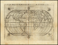
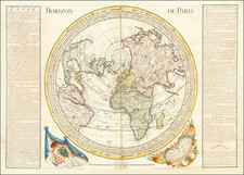
Intriguing Venetian World Map
Fascinating world map showing an antiquated geography for its publication date of 1807. Many of the map’s details appear outdated for the turn of the nineteenth century, which was a feature of most of Pasquali’s work.
On a Mercator Projection, the most noticeable feature is the massive Terre Artiche. Although a Northwest Passage is still possible, and Greenland is attached to Canada, the imposing continent looks nearly impossible to skirt. There is a peninsula in the west that resembles Alaska, but it is much rougher than other contemporary maps.
The Pacific Northwest of North America includes an odd cutout, suggesting a sea or bay, much like earlier iterations of the Sea or Bay of the West. Interestingly, the findings of the third Cook voyage (1776-1780) and the Vancouver expedition (1791-1795) are not integrated in the North Pacific, but the outline of New Zealand, delineated on Cook’s first voyage (1768-1771) is shown.
Another odd-holdover is the amalgamation of Australia with Pedro Fernandes de Quiros’ Austrialia de Espiritu Santo, which is actually Vanuatu, and New Guinea. On Cook’s first voyage, he sailed through the strait between New Guinea and Australia, which is called the Torres Strait after Luís Vaz de Torres, Quiros’ second-in-command, who sailed through it in the early seventeenth century. The Spanish suppressed Torres’ report in the hopes of maintaining power via geographic secrecy. The strait was only rediscovered by Alexander Dalrymple in 1762, when he was researching documents captured from the Spanish in the Philippines during the Seven Years’ War.
As for Pasquali’s Terra di S. Spirito in Australia, Quiros had contacted Vanuatu on his second Pacific voyage of 1605. He thought it was part of a continent and told officials in Europe as much. He died before he could mount another expedition, but his ideas were reprinted in prominent voyage collections into the eighteenth century.
Cartographically, there was variation in the placement of a hypothetical eastern Australian coastline that included Espiritu Santo. One of the earliest maps to show this depiction seems to have been Guillaume Delisle’s 1714 map of the southern hemisphere. The map shows Espiritu Santo with the Jordan and San Salvador rivers at roughly 185°E (from an Atlantic prime meridian), but it is not connected to New Holland. Others also adopted the idea of an Australian continent stretching to Espiritu Santo, including Richard Cushee in his 38 cm. diameter terrestrial globe of 1731.
The idea of a hypothetical eastern coast, evident in the famed Bonaparte Tasman map, was revived in the 1740s and 1750s. One of the world maps in John Campbell’s collection, by Emmanuel Bowen, shows T. de St. Espirit at 150°E (Greenwich meridian) as part of a suggested eastern coastline for Australia.
In 1753, Bellin connected Van Diemen’s Land to Espiritu Santo (145°E, Paris meridian), but added a note explaining the link as unproven. Robert de Vaugondy’s map of 1756 also connects the two into a large continent with New Holland (Espiritu Santo at 170°E, with an Atlantic meridian). Interestingly, the latter map was included in De Brosses’ voyage collection, wherein De Brosses expressed his belief that Espiritu Santo was insular.
The depiction largely died out by the end of the eighteenth century, due to Cook’s first voyage and subsequent voyages by traders and explorers. Its inclusion here is certainly an oddity.
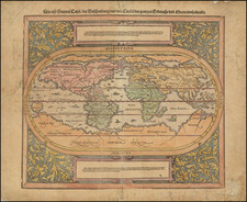
Many European maps of North America in the eighteenth century depict a large, western inland sea, hundreds of miles in diameter, with a small inlet to the Pacific and even some interior islands. The origins of this myth can be traced to several different sources and are tied to the search for a Northwest Passage. Like many cartographic myths, the Sea of the West persisted for decades, even in the face of strong evidence pointing to its non-existence.
One of the first European navigators to supposedly explore this area was Martin Aguilar. A Spanish captain, he sailed with Sebastian Vizcaino on a reconnaissance expedition up the California coast in 1602-3. Aguilar, commanding the Tres Reyes, was blown off course, to the north. When the seas calmed, Aguilar reported that he had found the mouth of a large river. Eighteenth-century geographers later conjectured that the river was the entrance to the Sea of the West.
Other maps placed the entrance to the Sea of the West via the Juan de Fuca Strait. Juan de la Fuca is the Castilianized name of Greek navigator Ioánnis Fokás (Phokás). Little archival evidence survives of Fuca’s career, but a chance meeting with an English financier, Michael Lok, in Venice in 1596 gave birth to rumors of Fuca’s voyages in the Pacific. Fuca reported that he had been sent north from New Spain twice in 1592 in search of the Strait of Anian. The Spanish Crown failed to reward Fuca’s discovery of an opening in the coast at roughly 47° N latitude and Fuca left the Spanish service embittered. His story lived on in Lok’s letters and eventually was published in Samuel Purchas’ travel collection of 1625. On many eighteenth-century maps, Fuca’s Strait is linked with a River or Sea of the West. In 1787, the present-day Juan de Fuca Strait was named by the wife of naval explorer Charles William Barkley, making permanent a label that had previously just been hopeful guesswork.
The source of the modern (18th Century) myth of the Sea or Bay of the West (Baye ou Mer de L'Ouest in French), are manuscript maps by Guillaume De L'Isle, who served as the Royal Geographer to the King of France at the end of the 17th Century and beginning of the 18th Century and is widely regarded as the most important map maker of his time. There is a map in Yale's map collection, which depicts a 16th Century Thames school map of North America with a large, "Branch of the South Sea," which closely resembles De L'Isle's Mer de L'Ouest, and may well be the source of De L'Isle's idea.
At the end of the 17th Century, Guillaume De L'Isle had access to the best available maps of the interior of North America, which were being provided from a number of missionary sources, as the French Missionaries pushed west of the Great Lakes and the Mississippi River and obtained information from the indigenous Indian tribes. De L'Isle was regularly producing and updating his manuscript maps in an attempt to integrate new and often conflicting information and improve upon the existing maps of North America. Many of his maps can be viewed as drafts, which were discarded in favor of other and considerably different models.
There are several De L'Isle manuscripts in the Bibliotheque Nationale de France, prepared as early as 1696 (dated), that depict this cartographic myth. Interestingly, while De L'Isle was a prolific publisher of printed maps, he never depicted the Sea or Bay of the West on any of his printed maps, which strongly suggests that he was not able to reconcile this information with the best available source information from America. During this same period, Jean Baptiste Nolin, who had in the prior decade collaborated with Vincenzo Maria Coronelli on his monumental globe for Louis XIV and produced a series of highly important maps of North America and its regions, would have also had access to many of the same reports and maps as De L'Isle. Nolin apparently gave greater credence to the concept than De L'Isle.
The earliest printed map to show the Bay of the West is Jean Baptiste Nolin's rare wall map of the world, published in about 1700. Nolin plagiarized the idea from Guillaume De L'Isle, as he testified when suing Nolin for plagiarism. He said, the Sea of the West “was one of my discoveries. But since it is not always appropriate to publish what one knows or what one thinks one knows, I have not had this sea engraved on the works that I made public, not wanting foreigners to profit from this discovery” (as quoted in Pedley, The Commerce of Cartography, 109). The court sided with De L'Isle and issued an order requiring Nolin to destroy the copper plates for the map (see Shirley 605). Nolin's map was in turn copied by the Mortier family, who issued 3 world maps shortly thereafter, showing Nolin's version of the Sea of the West, but the myth ignored for nearly half a century.
While the myth of the Sea or Bay of the West temporarily languished, the proliferation of Russian exploration off the Northwest Coast of America after 1740, as reported by Guillaume's younger brother Joseph Nicholas De L'Isle, reinvigorated interest in the region and forced the most prominent map makers of the period to re-examine existing knowledge. Joseph Nicolas served as a geographer to the Russian Academy and returned with this information to Paris. The re-introduction of the sea in the mid-eighteenth century was the result of Guillaume De L’Isle’s son-in-law, Philippe Buache’s review of his father-in-law’s papers. Although Guilluame De L’Isle never published a printed map showing the sea, he had postulated that it could exist, and that it might connect to a Northwest Passage through New France, not through English territory farther north.
The sea was a major part of Buache and Joseph-Nicholas Delisle’s maps of the North Pacific, published in the 1750s. While controversial, the features of those maps were quickly copied by other mapmakers, including the Sea of the West. The inland body of water lingered on maps until the later-eighteenth century.
During a period between 1750 and 1770, the most prominent French and British map makers advanced multiple and widely varying theories on the Northwest Coast of America. Denis Diderot dedicates several of the 10 maps in his monumental Encylopedie (1779 and after), to a comprehensive survey of the maps proffered by Joseph Nicholas De L'Isle (Guillaume's brother), Philippe Buache, Thomas Jefferys and others. The debate ended with Captain James Cook's and later George Vancouver and Comte Jean de la Perouse's explorations in the late 18th Century.