|
||

|

|
|

|
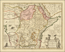
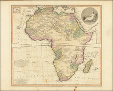
Africa, a map engraved by Thomas Jefferys and released in London in 1750, captures a riveting perspective on the African continent during the mid-18th century. Detailed with both conjectural and factual geographical annotations, the map sheds light on the prevailing European understanding of Africa's vast expanse during this epoch. With its multitude of place names—both real and imagined—it provides a panoramic glimpse into the evolving cartographic knowledge of the time.
The mid-18th century was a period of exploration, colonial expansion, and burgeoning scientific curiosity. European expeditions were increasingly venturing into the heart of Africa, driven by a thirst for knowledge, commerce, and territorial acquisition. This map encapsulates these endeavors, with its blend of known territories and speculative regions, emblematic of the mysteries the continent still held for European explorers.
Thomas Jefferys's mapping technique is a testament to the cartographic methodologies of the period. The delineation of contemporary geo-political borders reflects the European understanding and claims on the continent, while the conjectural details underline the challenges faced by cartographers. The inclusion of Jefferys's signature alligator—an image often found on his engravings—adds an artistic flourish to the map, anchoring it firmly in the Jefferys tradition.
This representation of Africa, marked with its blend of certainty and speculation, stands as an intriguing artifact from an era of discovery and imperial ambition. Its combination of artistry and cartographic detail, underscored by Jefferys's emblematic alligator, offers a unique window into the European perception of Africa during the mid-18th century.
Thomas Jefferys (ca. 1719-1771) was a prolific map publisher, engraver, and cartographer based in London. His father was a cutler, but Jefferys was apprenticed to Emanuel Bowen, a prominent mapmaker and engraver. He was made free of the Merchant Taylors’ Company in 1744, although two earlier maps bearing his name have been identified.
Jefferys had several collaborators and partners throughout his career. His first atlas, The Small English Atlas, was published with Thomas Kitchin in 1748-9. Later, he worked with Robert Sayer on A General Topography of North America (1768); Sayer also published posthumous collections with Jefferys' contributions including The American Atlas, The North-American Pilot, and The West-India Atlas.
Jefferys was the Geographer to Frederick Prince of Wales and, from 1760, to King George III. Thanks especially to opportunities offered by the Seven Years' War, he is best known today for his maps of North America, and for his central place in the map trade—he not only sold maps commercially, but also imported the latest materials and had ties to several government bodies for whom he produced materials.
Upon his death in 1771, his workshop passed to his partner, William Faden, and his son, Thomas Jr. However, Jefferys had gone bankrupt in 1766 and some of his plates were bought by Robert Sayer (see above). Sayer, who had partnered in the past with Philip Overton (d. 1751), specialized in (re)publishing maps. In 1770, he partnered with John Bennett and many Jefferys maps were republished by the duo.