|
||

|

|
|

|
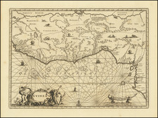
A small yet significant by Petrus Bertius illusrating the a portion of western part of Central Africa, specifically the Congo region.
The map illustrates a complex network of rivers, coastlines, and internal regions, all rendered with delicate precision. At a glance, one can see the emphasis on the Rio Zaire (Congo River), the main artery in to the interior region.
Engraved by the celebrated cartographer Jodocus Hondius before 1616, this map was first published in Petrus Bertius's revised pocket atlas "Tabularum Geographicarum Contractarum Libri septem," a 1616 edition that aimed to condense geographical knowledge into a portable format.
The map's plates led a fascinating life of their own. According to Peter van der Krogt in "Atlantes Neerlandici," volume IIIA, page 442, these same plates were borrowed to illustrate other notable works. These include Paullus Merula's "Cosmographia Generalis," printed in Leiden by Isaac Elsevier in 1621, and the "Wereld Spiegel" by Cloppenburch.
In the 1630s, the plates found their way into the possession of Willem Jansz. Blaeu, probably acquired alongside the plates for Jodocus Hondius Jr.'s Appendix. The plates were then used again for the Merula edition of 1635/36. Even Joan Blaeu utilized these plates, producing an Atlas Minor without text.
The Congo region, depicted in this map, experienced significant transformations during the first half of the 17th century. The Kingdom of Kongo, a prominent state in the region, had established ties with the Portuguese since the late 15th century
Petrus Bertius was a Flemish historian, theologian, geographer, and cartographer. Known in Dutch as Peter de Bert, Bertius was born in Beveren. His father was a Protestant preacher and his family fled to London around 1568. The young Bertius only returned to the Low Countries in 1577, to attend the University of Leiden. A bright pupil, Bertius worked as a tutor and was named subregent of the Leiden Statencollege in 1593. He ascended to the position of regent in 1606, upon the death of the former regent, who was also Bertius’ father-in-law. However, due to his radical religious views, he eventually lost his teaching position and was forbidden from offering private lessons.
His brothers-in-law were Jodocus Hondius and Pieter van den Keere, who were both prominent cartographers. Bertius began his own cartographic publishing in 1600 when he released a Latin edition of Barent Langenes’ miniature atlas Caert Thresoor (1598). He published another miniature atlas that first appeared in 1616.
By 1618, Bertius was named cosmographer to Louis XIII. He converted to Catholicism and took up a position as professor of rhetoric at the Collège de Boncourt (University of Paris). In 1622, Louis XIII created a chart of mathematics specifically for Bertius and named him his royal historian. He died in Paris in 1629.
![[West Coast Africa: Sierra Leone, Liberia and Guinea]](https://storage.googleapis.com/raremaps/img/small/40123.jpg)
![[ Nigeria ] The Central & Eastern Provinces of Southern Nigeria 1910. Compiled Under The Authority of His Excellency Sir Walter Egerton K.C.M.G. Governor and Commander-In-Chief . . .](https://storage.googleapis.com/raremaps/img/small/96351.jpg)