|
||

|

|
|

|
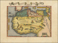
Johann Christoph Homann's map illustrates the area of present-day Morocco, split into the four kingdoms: Fessanum, Segelmeses, Marocca, and Tafliet. Further features include the Canary Islands, a small map of Madeira, and depictions of the cities of Marocco (Marrakesh) and Mequinetz.
In the north, the Kingdom of Fessanum, or Fez, was an important region during the medieval period, known for its cultural influence and the University of Al Quaraouiyine. Homann's map provides a detailed view of this region.
The southern Kingdom of Tafliet (Tafilalt) was home to the Alaouite dynasty. This region was a crucial area for trans-Saharan trade during the 17th century, which is indicated in Homann's depiction.
The Kingdom of Segelmeses is also present in Homann's map, and is referenced in a number of early travel guides of the 16th, 17th and 18th Centuries.
Additionally, the map includes the Canary Islands and an inset map of Madeira. The Canary Islands, although closer to Africa, were politically tied to Spain and served as a stopping point for ships traveling to the Americas. Madeira, a Portuguese archipelago, was known for its strategic location and sugar production.
The title cartouche of the map contains traditionally costumed figures and animals such as an ostrich, lion, and snake, reflecting the European view of Africa. The figure carrying a gun might be an indication of the warfare of that era. An unidentified young ruler's portrait is included, suggesting the dynastic leadership of the region.
Views of Marrakesh and Mequinetz (Meknes) are drawn along the bottom.
![[St. Helena] Vera effigies et delineatio Insulae Sanctae Helenae qua Ortum Occasium, et Septentrionem spectat . . . / The true description, and Scituation of the Island of St. Helena on the East, North and West Sydes, lyuning under 16. degrees on the Southsyde of the Equinoxiall line.](https://storage.googleapis.com/raremaps/img/small/69465.jpg)