|
||

|

|
|

|
Stock# 93830
Description
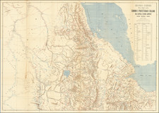
Political map with relief shown by hill shading, tinting and spot heights. Shows transport links, oil and gas fields, places of interest, and international and administrative boundaries.
The map features an additional six inset maps, three focused on Tarabulus and three on Benghazi.
The verso image features political, economic, and environmental information about the area.
Condition Description
Folding map, printed both sides. Very minor signs of wear at folds.
![[ Algerian Viticulture ] Carte Viti-Vinicole de l'Algerie](https://storage.googleapis.com/raremaps/img/small/97857.jpg)