|
||

|

|
|

|
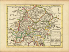
First Scientific Mapping of the Upper Rhine River Valley
Rare separately published map of Alsatia and the Upper Rhine River Region, first published by Georg Friedrich Meyer in Basle in 1677.
Oriented with west at the top, the map cover the region from the northern parts of the Bern Canton and Franche-Comte (and the sources of the Rhine in the Alps), to the area around Speyer and Philippsburg in Germany, covering a roughly 200 mile stretch of the region largely on the German-French border.
Georg Meyer's map of Alsatia is one of the first locally produced and scientifically constructed maps of the region. Meyer's first work of note was a map of the Count of Pfirt (Accurata et geographica Delineatio Comitate Pheritensis), published in 1667, for which no known example has survived to modern times. The success of the map inspired Basle authorities to give engineer Jakob Meyer a leave of absence from his duties to complete field observations to improve upon the work of Daniel Specklin (1536-1589), whose Elsass ist der vier Provinzen eine im teutschen Land, first published in 1576, was the first important map of the region, and widely copied by the major mapmakers of the period, including Mercator, Quad, De Bry, Le Roy, Tassin and Sanson.
Jakob Meyer, the father of Georg Friedrich Meyer, was chosen for the task and from 1667 to 1670 he and his son, together with their assistants, carried out the work. The original map created by this survey no longer survives, but the engraved copy created by G. F. Meyer in 1677 and published by Johann Lucas Hoffmann in Basle is still extant. Compared with Specklin's map, the work is a significant improvement. In 1703 it was brought up to date and republished. The maker offers the following note on the map's creation:
This map was drawn by the author who himself traveled through this entire region and noted everything with the utmost precision. Hence, even though some descriptions might have already been published or may yet be published, they will undoubtedly have to yield to this one, especially those sketched by authors who have not seen the region for themselves and are not familiar with this region. The author was Georg Fridericus Meijerus, a renowned geographer and architect from Basel.
The map was both important and influential and was copied by Jacob Sandrart in 1702 in Nuremberg.
The text regarding Alsace translates as follows:
ALSATIA, commonly known in German as Elas, as some believe, takes its name from the Ill river and the adjacent town of Ella, where ancient coins were excavated. This region is one of the most beautiful German provinces, boasting beautiful, cultivated, and delightful valleys, which are divided by the flowing Rhine. One part faces the west and is further divided into upper and lower Alsace. Specifically, there are the upper and lower parts of Brisigavia (Breisgau). The north is bordered by the Hercynian Forest, the south partly by Switzerland, the territories of the Bishop of Basel, and Burgundy, the west by the Vosges mountains, and the east by the Lower Palatinate. The fertility of the region speaks of the contest between Ceres (goddess of agriculture) and Bacchus (god of wine), from where daily essentials are exported to other nations, fish-rich rivers and lakes, and forests abundant with fruits and wildlife. However, as Mars, the destroyer of other provinces, did not spare this one, many of its cities, fortresses, and towns lie in ruins. Therefore, this current map offers the viewer nothing but a clear view of the region's face, shining brilliantly before war overtook it.
Rarity
The map is very are on the market.
![[ Rare Imprint -- Theater of War in Europe ] Le Royaume de France divise en Toutes ses Provinces / Groot Toneel des Oorlogs, tusschen de Geallierrede Moghendhen en het Fransche Ryk -- Grand Theatre de la Guerre entre les Puissances Alliees et L'Empire Francois . . .](https://storage.googleapis.com/raremaps/img/small/104046.jpg)
![[Heidelberg] Der löblichen und weitbekannten Statt Heidelberg, am Wasser Neccar gelegen](https://storage.googleapis.com/raremaps/img/small/94871.jpg)