|
||

|

|
|

|
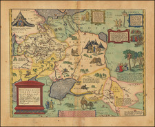
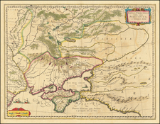
Rare map of the Theater of War in Finland, illustrating the territories involved in the Russo-Swedish War of 1741–1743.
Published in 1742, this cartographic artifact offers an invaluable contemporaneous perspective on a conflict that would culminate in the Treaty of Åbo and a consequential territorial reshuffling in the Baltic region.
The Russo-Swedish War of 1741–1743, commonly known as the Hats' War due to the Swedish political faction that championed it, unfolded against the backdrop of the broader War of Austrian Succession. The Swedish Hats party, driven by anti-Russian sentiment and the ambition to regain territories lost in previous conflicts, saw an opportunity to engage Russia, which was embroiled in a larger European war. However, the Swedish endeavor suffered from logistical failures and ineffective leadership, most conspicuously by Swedish military commander Charles Emil Lewenhaupt. On the Russian side, the war was directed under the auspices of the formidable Empress Elizabeth of Russia, whose troops were more successful in seizing key fortresses and territories.
The map focuses on the region around Finland, which was then a part of the Kingdom of Sweden, and contiguous parts of Estonia and the contiguous parts of Russia.
The Treaty of Åbo in 1743 effectively ended hostilities and had the profound consequence of ceding parts of southeastern Finland to Russia, shifting the balance of power in the region.
![[ Map of Modern Europe in Faces ] Карта современной Европы въ лицаx](https://storage.googleapis.com/raremaps/img/small/98887.jpg)