|
||

|

|
|

|
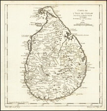
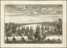
Plan of the Bay and Harbour of Trincomalay, on the Island of Ceylon, executed under the order of Admiral Cornish and sourced from M. D'Apres de Mannevillette, was finely engraved and disseminated by Laurie & Whittle in London, circa 1798. The map offers a meticulous topographical and bathymetric representation of the bay, illustrating underwater topographies, such as the layout of rocks and sands, alongside important navigational aids for sailors of the era.
Trincomalay, known today as Trincomalee, boasts one of the world’s finest natural harbors, and its strategic significance during the late 18th century cannot be overstated. Amidst the geopolitical flux of European powers in Asia, the control and understanding of such pivotal maritime locations were paramount. Trincomalay's portrayal, in a period where Britain's naval power was ascendant, underscores its geopolitical and naval significance during a critical juncture in colonial history.
The map delineates several key features: soundings which provide depth information for safe anchorage, the exact marks for hazards, and directives for navigational strategies. The vivid detail regarding "Double Lines" and "Single Lines" aids in discerning the exact dangers and how to avoid them. These soundings and marks were crucial for the safe navigation and anchoring of vessels, revealing the harbor’s complexities and the surrounding bay's unique characteristics.
Among the annotations, the tragic fate of His Majesty's Ship Diomede, lost in 1795 after striking the aptly named Diomede's Rock, offers a somber testament to the perils of navigating unfamiliar waters, underscoring the value of such comprehensive charts. The map further elucidates optimal anchoring zones, like the area between Norway Island and Sambore River, where ships could find respite during unfavorable wind conditions, specifically during the northeast monsoon.
Within the extensive notations on tides, wind patterns, and navigational cues, the map serves as both a practical guide for mariners and a testament to the scientific rigor of 18th-century cartography. This cartographic artifact encapsulates the naval challenges and geopolitical intrigue of its era, offering profound insights into the maritime history of the Indian Ocean region.
Robert Laurie (ca. 1755-1836) and James Whittle (1757-1818) formed their Fleet Street, London-based firm upon the 1794 death of their employer Robert Sayer, himself one of the dominant print and mapmakers of the last half of the 18th century.
Laurie & Whittle started managing Sayer's business as early as 1787. They took over all managerial duties when Sayer's health flagged in 1792, and they changed the imprint in 1794 upon his death. Sayer left the two a 21-year lease on the shop (at £100 a year) and on Sayer's Bolt Court premises, as well as an option to acquire stock and equipment at a preferential price of £5,000 payable over three years.
Robert Laurie retired from the firm in 1812, and his role was assumed by his son, Richard Holmes Laurie (1777-1858). The younger Laurie worked with James Whittle until the latter died in 1818. After R. H. Laurie died in 1858, Alexander George Findlay, FRGS (1812-1875) purchased the firm from his daughters. The firm continues today under another name, specializing in yachting charts.
Laurie & Whittle were prolific print and map publishers, and throughout their careers, they produced numerous very important and rare works. They carried on Robert Sayer's atlas business and were responsible for editions of The Complete East-India Pilot and The American Atlas.

![[Sri Lanka] Tabula Asiae XII](https://storage.googleapis.com/raremaps/img/small/87852.jpg)