


|
||

|

|
|

|
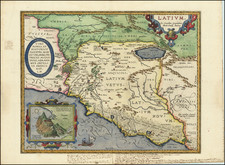
This is a fabulous town plan of Ancient Rome by William Barnard Clarke, including a description and location of many of the ancient walls and buildings that made up the city. This view of the imperial city strips away the many layers of later development, allowing the viewer to fully understand the city and its seven hills.
The map is attractively laid out, showing the city within the Aurelian walls. While the heart of the new city lies slightly to the north of most of the buildings on the map, the center of old Rome was in the hillier southern area. The location of the Sublician Bridge (Pons Sublicius), the earliest known bridge in ancient Rome, is noted, connecting XIV Transtiberina (the modern-day neighborhood of Trastevere) to the rest of Rome. The structure of the ancient capital is easily visible, which is likely due to the talent of the cartographer, William Barnard Clarke. This was Clarke's first map for the SDUK and showcases both his interest in ancient Italian history and his knowledge regarding archeology, having been previously in charge of the restoration of the 13th Century Waltham Cross in London.
A profile of ten famous structures lies at the bottom. These include the Pantheon, the Colosseum, Trajan's Column, and the Arch of Constantine. An index of buildings grouped according to regions of Rome appears along the left of the map. Copious notes describe the geography of the city and its history.
William Barnard Clarke was a multifaceted Englishman renowned for his numerous contributions in the realms of architecture, cartography, archaeology, and the arts. Born in 1806, his profound influence extended across various domains, making him one of the distinguished personalities of his time.
As an architect, in 1831, Clarke played a pivotal role in the founding of the Architectural Society of London and served as its inaugural president.
Clarke was a mapmaker of note, especially for his association with the Society for the Diffusion of Useful Knowledge (SDUK). Established in 1826, the Society aimed to make knowledge accessible to a broader audience, and Clarke's contributions played a significant role in that mission.
Clarke's initial work for the Society in 1830 was a Celestial Atlas, a set of six maps that detailed the stars. These maps amalgamated information from scientifically-informed sources and were supervised by Sir John Lubbock. They were lauded not only for their exemplary execution but also for being reasonably priced, resonating with the Society's ethos of wide dissemination.
By this time, Clarke had garnered recognition as a proficient artist-draftsman. Over the subsequent decade, he dedicated himself to crafting a series of European city maps. While these weren't original surveys, Clarke's dedication saw him frequently traveling to authenticate specific details. These maps were also adorned with architectural views and cameos, usually positioned at the bottom of each sheet.
A highlight among his works was the "Plan of Ancient Rome," engraved by J. and C. Walker and released in 1830. This map was accompanied by a complementary "Plan of Modern Rome." Clarke's repertoire also included detailed plans of European cities like Warsaw, Milan, Frankfurt am Main, Berlin, Turin, Paris, St Petersburg, London, Florence, Genoa, Venice, Amsterdam, Moscow, Copenhagen, and Stockholm throughout the early 1830s. Clarke's meticulous plans and maps, renowned for their precision and detail, remain collectible items to this day.
While primarily known for his mapmaking prowess, Clarke's architectural skills are evident in his Guide to Hayling (1836), showcasing Hayling Island in Hampshire as an emerging tourist destination. The illustrations, with architectural nuances similar to those in his city plans, were notably his handiwork.
Clarke's profound interest in archaeology is also reflected in his work on Pompeii. He collated materials for a two-volume work on the excavations at Pompeii, initially published in 1831-1832, and then republished in 1836. The work was later translated into German and published in Leipzig. Clarke's dedication to Pompeii didn't end with his writings. His personal collection was enriched with artifacts from the site, revealing his fascination with the ancient city.
By around 1840, Clarke's contributions to the SDUK seemed to wane. Subsequently, his travels led him to Italy, where he indulged in collecting art, sculptures, coins, and medals. He traveled extensively, visiting Switzerland, the Netherlands, and parts of Germany, further augmenting his collections.
![[Rome] Nouveau Plan De La Ville De Rome Tire Pare Ordre Du Pape Par Mateo Gregoria De Romans Tres Utille Pour Les Voiageurs](https://storage.googleapis.com/raremaps/img/small/91200.jpg)
![[Spanish Siege of Ostia] Il Vero Disegno Del Sito Di Hostia e Di Porto Con Li Forti Fatti Dal Campo Di Sua Santita et Delli Imperiali Qualisi Resero Adi XXIIII Genaro M. D. L V II . . . .](https://storage.googleapis.com/raremaps/img/small/75401.jpg)
![[Ancient Rome] Antiquae urbis perfecta et nova delineatio](https://storage.googleapis.com/raremaps/img/small/75180.jpg)
![[Ancient Rome] Antiquae Urbis Romae Imago Accuratiss Ex Vetustis Monumentis . . .Descripta a Pyrrho Ligorio Romano Per XIIII Regiones in Quas Urbem Divisit Imp. Caesar Augustus](https://storage.googleapis.com/raremaps/img/small/93681.jpg)
![[Ostia, the Harbor of Rome] Claudii Et Traiani Impp Admirabilium Portuum Ostiensium Orthographia Per Stephanum Du Perach Architectum Iuxta Antiqua Vestigia Accuratissime Delineata . . . 1581](https://storage.googleapis.com/raremaps/img/small/75639.jpg)