|
||

|

|
|

|
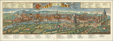
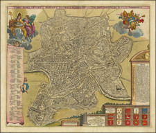
Finely colored antique map of Ancient Rome, published by Pieter van der Aa and inspired by the work of Renaissance mapmaker Pirro Ligorio
The map illustrates Rome at the time of Augustus Caesar, seeking to depict Rome in its grandeur and detailed complexity. At the center of the map is the Tiber River, crossing the city and portrayed with exquisite detail. Seven bridges span across the river, each painstakingly labeled with ancient Roman scripts. Noteworthy is the Pons Aemilius, the oldest stone bridge in Rome, captured in its original glory.
The map showcases an array of fortifications, intricate architecture, and landmarks. Notably, it features the Colosseum, the Circus Maximus, and the Pantheon in minute detail, attesting to the grandeur of Rome under Augustus. The Roman Forum, the political, legal, and religious heart of the city, is meticulously depicted with its surrounding temples, basilicas, and public spaces. It also presents the Servian Wall, the fortification built around Rome in the 4th century BC, indicating the protective measures undertaken by the ancients.
The map includes a key, providing brief descriptions and references to 269 points of interest. Each key corresponds to a numerical notation on the map, allowing for a comprehensive exploration of the city.
Pirro Ligorio
Pirro Ligorio, born around 1513 in Naples, Italy, was a multifaceted and distinguished figure of the Renaissance era. An architect, antiquarian, archaeologist, and garden designer, Ligorio's legacy is imbued in many famous structures, including parts of the Vatican's St. Peter's Basilica and the Casino of Pius IV.
Ligorio's contribution to cartography is perhaps less well known but no less significant. Ligorio possessed an extraordinary passion for the ancient world, which led him to study and meticulously document the ruins of Rome. His detailed maps and plans of Ancient Rome, compiled with great dedication and scholarly rigor, provided a robust foundation for understanding the city's topography and architecture. His masterful drawings reflected a mix of accuracy and artistic flair that made them invaluable to subsequent generations of cartographers.
Pieter van der Aa (1659-1733) was a Dutch mapmaker and publisher who printed pirated editions of foreign bestsellers and illustrated books, but is best known for his voluminous output of maps and atlases. Van der Aa was born to a German stonecutter from Holstein. Interestingly, all three van der Aa sons came to be involved in the printing business. Hildebrand was a copper engraver and Boudewyn was a printer.
![Veduta del tempio della Sibilla in Tivoli [View of the Temple of the Sibyl in Tivoli]](https://storage.googleapis.com/raremaps/img/small/93189.jpg)
![[Ancient Rome] Figura aereae civitatis Romanae](https://storage.googleapis.com/raremaps/img/small/77299.jpg)