|
||

|

|
|

|
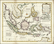
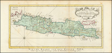
Published in London by Laurie & Whittle on October 12, 1798, A New Chart of the Eastern Straits, or the Straits to the East of Java, with a Part of the Banda Sea is a meticulous maritime chart, capturing the complex seafaring dynamics of the Eastern Straits. Including Java's eastern straits, Bali, Flores, and a section of the Banda Sea, the chart provides an intricate portrayal of this important maritime region during the late 18th century.
The chart exhibits a detailed view of the region's geography, marked with various historical nautical tracks. These include the routes of renowned expeditions, such as "The Endeavour" under Captain Cook, "The Lord Holland" under Captain Williams, and "The Earl of Mansfield" under Captain Fraser. Also noted are the tracks of "The Lord North," "The Warwick," and the legendary buccaneer William Dampier's expedition in 1699, providing an intriguing historical context to the map.
Incorporated within the chart are several inset views, plans, and coastal profiles. These include a depiction of the entrance of the Straits of Larantooca as observed by Captain Robert Williams in 1797, a depiction of a burning island (volcano) in the Banda Sea observed by the Taunton Castle in 1797, and a charting of the Western Passage of the Straits of Sapy.
Significantly, the chart also highlights discrepancies between different historical sources, as seen in the reference to the Dutch description of Wetter Island, which is not mentioned in Dampier's account. These subtle yet intriguing differences underscore the evolving nature of geographical knowledge during the period, hinting at the complexities and challenges of cartography.
A New Chart of the Eastern Straits, or the Straits to the East of Java, with a Part of the Banda Sea thus presents a fascinating blend of cartographic detail, nautical routes, and historical observations. Its robust depiction of this key maritime region, layered with references to important voyages and geographical disputes, ensures its enduring value as a snapshot of late 18th-century seafaring exploration and understanding.
Robert Laurie (ca. 1755-1836) and James Whittle (1757-1818) formed their Fleet Street, London-based firm upon the 1794 death of their employer Robert Sayer, himself one of the dominant print and mapmakers of the last half of the 18th century.
Laurie & Whittle started managing Sayer's business as early as 1787. They took over all managerial duties when Sayer's health flagged in 1792, and they changed the imprint in 1794 upon his death. Sayer left the two a 21-year lease on the shop (at £100 a year) and on Sayer's Bolt Court premises, as well as an option to acquire stock and equipment at a preferential price of £5,000 payable over three years.
Robert Laurie retired from the firm in 1812, and his role was assumed by his son, Richard Holmes Laurie (1777-1858). The younger Laurie worked with James Whittle until the latter died in 1818. After R. H. Laurie died in 1858, Alexander George Findlay, FRGS (1812-1875) purchased the firm from his daughters. The firm continues today under another name, specializing in yachting charts.
Laurie & Whittle were prolific print and map publishers, and throughout their careers, they produced numerous very important and rare works. They carried on Robert Sayer's atlas business and were responsible for editions of The Complete East-India Pilot and The American Atlas.
![[Java Sea, Java and Parts of Sumatra, Borneo, Bali & Madura]](https://storage.googleapis.com/raremaps/img/small/0249gh.jpg)