


|
||

|

|
|

|
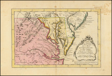
First Edition of De Brahm's Seminal Map of South Carolina and Part of Georgia
William Gerard de Brahm's A Map of South Carolina and Part of Georgia holds a significant place in the history of colonial American cartography, especially with respect to the Southeast. De Brahm, a German-born military officer who moved to Georgia in 1751, managed to portray large areas of the southern colonies with a degree of topographical accuracy previously unseen, due to his scientific approach to surveying.
After emigrating to the colonies, De Brahm quickly put his surveying skills to work. He served as a surveyor in both Georgia and South Carolina and eventually rose to the position of Surveyor General of South Carolina in 1754. During the first part of the decade, de Brahm conducted extensive coastal surveys, the results of which significantly informed the details in this map. Recognizing the value of local knowledge, de Brahm invited plantation owners to submit plats of their land, which he then incorporated into his map.
This large-scale map, boasting a scale of one inch to five miles, covers the coastal areas from the North Carolina boundary to the St. Marys River in Georgia, and then inland to the Indian Country. De Brahm's attention to detail is evident throughout, with the carefully rendered tidal channels, swamps, and marshes. He also marked out the boundaries of all the organized parishes in South Carolina and created an index of land holdings in the lower center of the map.
One unique feature of de Brahm's map is the analysis of the topography he observed along the border between North and South Carolina, a section of the map that appears almost like aerial photography. This element, however, was not included in the second state of the map in 1780.
Compared to its predecessors, de Brahm's map offered an unprecedented level of accuracy in the depiction of rivers, tributaries, islands, and parishes. Its cartouche, illustrating the colonies' indigo trade, served as an economic snapshot of the time.
First Edition of De Brahm's Map
De Brahm's map is the most important and influential map of South Carolina and Georgia during the British Colonial era. As noted by Cumming, "For the first time, for any large area of the southern colonies, a map possesses topographical accuracy based on scientific surveys."
As noted by Henry Taliaferro:
In 1752, De Braham announced plans to publish a new map of both colonies in an advertisement in the South Carolina Gazette, in which he invited plantation owners "who desire to have their particular Plantations inserted therein … to send copies of their respective Plats." The completed manuscript was sent to London where the Board of Trade approved it and commissioned Thomas Jefferys to publish the work. At the lower center is a dedication to Lord Halifax, the President of the Board of Trade.
The map is drawn on the grand scale of one inch equals five miles. It shows the coastal areas from the North Carolina boundary southward to St. Marys River in Georgia, then inland to the Indian Country. For the coastal region and up the major rivers as far as the settlements extend, great care and detail in surveying is evident. The amount of topographical information given in the low country is impressive; swamps, marshes, and the winding of tidal channels and rivers are delineated. The boundaries of all the organized parishes in South Carolina are laid down. At lower center is a lengthy index to land holdings in South Carolina, the obvious result of his address to planters in 1752.
De Brahm included an unusual feature along the border between North and South Carolina. Entitled "The Nature of the Land in this Course," it is an analysis of the topography De Braham observed when he ran the forty mile boundary line inland from the mouth of inland creek. It almost has the character of aerial photography. This feature was omitted from the second state of 1780.
Conclusion
De Brahm's map appeared in no standard atlases of the time, only being produced as a separate wall map or making its way into made-to-order composite atlases. It is consequently extremely rare today and generally accepted as one the of cornerstone maps of American colonial mapmaking and the mapping of the Southeast.
De Brahm's map is a remarkable representation of South Carolina and Georgia, offering an in-depth exploration of the land through the lens of a scientific surveyor. It set a new standard in the field of cartography and stands as a tangible link to the historical and socio-economic realities of the southern colonies during the British Colonial era.
Thomas Jefferys (ca. 1719-1771) was a prolific map publisher, engraver, and cartographer based in London. His father was a cutler, but Jefferys was apprenticed to Emanuel Bowen, a prominent mapmaker and engraver. He was made free of the Merchant Taylors’ Company in 1744, although two earlier maps bearing his name have been identified.
Jefferys had several collaborators and partners throughout his career. His first atlas, The Small English Atlas, was published with Thomas Kitchin in 1748-9. Later, he worked with Robert Sayer on A General Topography of North America (1768); Sayer also published posthumous collections with Jefferys' contributions including The American Atlas, The North-American Pilot, and The West-India Atlas.
Jefferys was the Geographer to Frederick Prince of Wales and, from 1760, to King George III. Thanks especially to opportunities offered by the Seven Years' War, he is best known today for his maps of North America, and for his central place in the map trade—he not only sold maps commercially, but also imported the latest materials and had ties to several government bodies for whom he produced materials.
Upon his death in 1771, his workshop passed to his partner, William Faden, and his son, Thomas Jr. However, Jefferys had gone bankrupt in 1766 and some of his plates were bought by Robert Sayer (see above). Sayer, who had partnered in the past with Philip Overton (d. 1751), specialized in (re)publishing maps. In 1770, he partnered with John Bennett and many Jefferys maps were republished by the duo.
![[ Georgia - Margravate of Azilia ] A Plan representing the Form of Setling the Districts, or County Divisions in the Margravate of Azilia](https://storage.googleapis.com/raremaps/img/small/101398.jpg)
![(The First Letter From British Florida) [September 5, 1763, Autograph Letter, Signed, from Robert Campbell to John Campbell, 4th Earl of Loudoun, describing the British taking possession of Florida and the state of the settlement of Pensacola]](https://storage.googleapis.com/raremaps/img/small/86620.jpg)
![[ Savannah, Georgia ] [Manuscript document on vellum:] The City of Savannah. The Police Office. Circular. An Address to the Citizens and Inhabitants of the United States... January 12th 1820... Circular to the Governors of the Several States, Mayors, Intendants, Police Magistrates... January 13th 1820... Georgia -- Police Office -- City of Savannah, January 25th 1820...](https://storage.googleapis.com/raremaps/img/small/90741.jpg)
![[Rare Blaeu West Indische Pascaert Wall Map Section] Insulae Americanae in Oceano Septentrionali, cum terris adjacentibus](https://storage.googleapis.com/raremaps/img/small/75672.jpg)