|
||

|

|
|

|
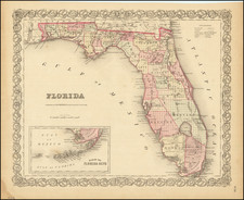
The late 19th-century Rand McNally map of Florida, published in 1892, presents a rich tapestry of the state’s geographical and historical landscape during a period of growth and transformation. The map stands as a meticulous chronicle of the pre-boom era, prior to the significant economic expansions of the 20th century.
The final 2 decades of the 19th Century in Florida were marked by rapid development and population growth. The economy, previously dependent on agriculture, primarily cotton and citrus, began to diversify. Lumber and naval stores became significant industries, and the sponge trade, centered around the town of Tarpon Springs, started to thrive. The railroad industry also saw an uptick in development, playing a pivotal role in the state's growth. The arrival of the railroad heralded enhanced connections between Florida's towns and cities and improved accessibility to the state's bounty of natural resources.
The Rand McNally map is a testament to this transformative period. The map showcases an extensive network of early railroad lines, etching a metallic spiderweb across the state's diverse terrain. These lines serve as an emblem of progress, demonstrating the burgeoning industry's role in linking Florida's communities and facilitating the transportation of goods and passengers.
Two detailed insets augment the richness of the map, focusing on particular regions of Florida. The first is an enlarged depiction of parts of Lake, Orange, and Volusia Counties, offering a closer examination of the Orlando region. This particular area was known for its abundant citrus groves and had begun to flourish due to the new railroad connections. The map's detailing of this region reveals a glimpse into the area's agricultural landscape before the tourist boom of the 20th century.
The second inset concentrates on southern Florida, a region undergoing its own unique transformations. While still largely undeveloped at this time, the area was beginning to feel the influence of the railroad, and plans were underway for the extension of the Florida East Coast Railway to Miami by industry tycoon Henry Flagler.
Rand McNally & Co. is a large American map and navigation company best known for its annual atlases. The company got its start in 1856, when William Rand opened a print shop in Chicago. He was joined in 1858 by a new employee, Andrew McNally. Together, the men established their namesake company in 1868. Originally, the company was intended to print the tickets and timetables for the trains running to and through Chicago; their first railway guide was published in 1869.
By 1870, they had shifted from just printing to publishing directories, travel guides, and newspapers. Their first map appeared in 1872 in a railway guide. The map was produced using a new wax engraving method, a cheaper process that gave the company an edge.
By 1880 Rand McNally had entered the education market with globes, wall maps, and geography texts for students. In 1923, Rand McNally published the first Goode’s World Atlas, named after its editor, Dr. J. Paul Goode. For generations afterward, this would be the standard classroom atlas.
In 1899, William Rand left the company, but McNally and his family remained, controlling the company for over a century. In 1904, they published their first road map intended for automobiles and by 1907 were publishing Photo-Auto Guides, which combined photography and mapping to help drivers. In 1924, they produced the Auto Chum, a precursor to their famous road atlases. Rand McNally would remain the leader in road maps and atlases throughout the twentieth century.
In 1937, Rand McNally opened its first store in New York City. Ever on the frontier of technology, Rand McNally pioneered the scribing process for printing tickets in 1958 and printed their first full-color road atlas in 1960. Arthur Robinson developed his now-famous projection of Rand McNally in 1969. By the 1980s, the company was exploring digital reproduction and digital databases of maps for truckers. In the 1990s, they lead the charge to develop trip-planning software and websites. Today, most of its products are available online or in a digital format, including maps for tablets and phones.

![[French Colonization in Florida and the Southeast] La Floride Francoise Dressee sur La Relation des Voiages que Ribaut, Laudonier, et Gourgues y ont faits in 1562, 1564 et 1567 . . .](https://storage.googleapis.com/raremaps/img/small/91072.jpg)