|
||

|

|
|

|
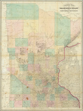
Mapping the Pacification of the Northern Plains.
With Significant Manuscript Annotations.
This lithographed military map, published in 1869 under the auspices of Bvt. Brig. Gen. S.B. Holabird, Chief Quarter Master, Department of Dakota, and printed by Rice & Reed, St. Paul, constitutes a tour-de-force mapping of the Plains Indian Wars in the north. Encompassing much of the present-day territory of North Dakota, extending from the eastern banks of the Red River to the western reaches of the Missouri River, and spanning from Breckenridge, Minnesota, in the south, to the Canadian border in the north, this map offers a comprehensive depiction of the post-Dakota Uprising punitive campaigns.
The Aftermath of the 1862 Dakota Uprising
The Dakota Uprising of 1862 was a significant armed conflict that erupted between the Dakota (Sioux) tribes and the United States government in Minnesota. The conflict was rooted in a complex web of grievances, including broken treaties, withheld annuity payments, and mounting tensions due to encroachment on tribal lands by settlers and traders. In August 1862, a series of violent incidents culminated in a full-scale rebellion led by members of the Santee Sioux. The uprising resulted in attacks on frontier settlements, causing widespread devastation and loss of life. Subsequent to the suppression of the rebellion, the U.S. government launched punitive campaigns aimed at subduing the Sioux tribes and restoring order to the region. These military expeditions, led by Generals Henry Hastings Sibley and Alfred Sully, sought to quell resistance, punish those involved in the uprising, and establish military control over the Plains. The campaigns' objectives were threefold: to ensure the safety of settlers (raids into Minnesota continued into 1863), to punish any participants in the rebellion who had escaped after the initial crackdown, and to exert authority over the native tribes. These would become vital components of the broader context of westward expansion and Native American–U.S. government relations during this pivotal era in American history.
The present map provides perhaps the best near-contemporary cartographic documentation of the 1863 punitive campaigns against the Santee Sioux. Notable engagements such as the "Big Mound Battle Field Genl. Sibley July 24th, 1863," and the "Battle Field White Stone Hill Genl. Sulley (sic.) Sept. 3d, 1863," are prominently designated, along with the corresponding trails of both military leaders, thereby furnishing critical insights into the strategic maneuvers and events that unfolded during these significant campaigns. It delineates the course followed by General Sibley in his pursuit of the Santee Sioux from the Battle of Big Mound to Apple Creek and the Missouri River. Notably, the tragic events that ensued after Sibley's perceived success in the campaign, wherein the Sioux attacked a riverboat, resulting in the loss of 22 civilian lives, is memorialized through the toponym "Burnt Boat I," marking a nearby island.
The Twining Expedition of 1869
On July 1, 1869, Captain W. J. Twining of the Corps of Engineers led a reconnaissance survey into northern Dakota under orders from the headquarters of the Department of Dakota. The primary objective of this survey was to explore and assess the region lying east of longitude 100° 30'. The survey consisted of five distinct lines: (1) a route from Fort Abercrombie to Fort Totten, (2) a path from Fort Totten to St. Joseph, crossing the headwaters of the western tributaries of Red River and returning west of Devil's Lake, (3) a journey from Fort Totten to Mouse River and Turtle Mountain with a return, (4) a direct trail from Fort Totten to the south bend of Mouse River, and (5) a route from Fort Totten to Georgetown on the Red River.
After departing Fort Totten on September 6, the party was escorted by Lieutenant Lacristo of the Twentieth Infantry, thirty enlisted men, and four Indian scouts. The surveying process involved the use of a small compass and odometer to map the routes, which were corroborated with frequent astronomical observations to determine latitude accurately.
The final report of the reconnaissance, along with the field notes and astronomical observations, was presented to the department commander on February 20, 1870. In 1889, Wheeler's Report on the Surveys West of the Hundredth Meridian (page 631) stated that the map of the survey remained incomplete and that its findings were integrated into "the maps of northern Dakota", presumably the 1875 Topographical Engineers' map of the Dakota Territory. Moreover, the report, field notes, and astronomical observations proved valuable resources for the United States Northern Boundary Commission's work conducted between 1872 and 1874.
Manuscript Annotations
The map bears significant contemporary manuscript annotations and corrections, attributed to an anonymous author evidently possessing extensive local knowledge. These additions are found throughout the map, often apparently involving the erasure of printed content, although definitive confirmation is hindered by the lack of a high-quality comparative image. The manuscript's focus is primarily limited to the watershed of the Red River, and the annotations provide valuable information on distances, routes, landmarks, and notable locations within the region. Specific additions include notations such as "127 Miles from Gerogetown to Pembina," reference to the "Wagon Road 26, 17, 12, 16, Ten miles Pt." along the Red River, and the location of "Site of Ft. G.H. Thomas" near Pembina. Additionally, a southwest-heading road from Pembina is delineated with double dashed lines, while a trail south of Pembina River is crossed out. The manuscript annotations also mention names like "Peter Van's," "Wilson Mail St," "Storm St," "Sibley's Crossing Mail Station," "Mail Station" near Big Slough, and "Minnewakan Lake or [DEVILS LAKE]," providing further insights into historical mail stations and geographic landmarks within the region. These contemporary additions significantly enrich the map's historical value, serving as a valuable resource for researchers and enthusiasts seeking detailed information about the geographical and human landscape of the area during the 1860s.
The Coming of the Railroad
Equally noteworthy is the temporal significance of this map's creation, coinciding with a momentous juncture when the construction of the North Pacific Railway was soon to commence, traversing the very region captured in the map. Thus, the map encapsulates a crucial transitionary moment in westward expansion, covering the period when the Sioux were displaced from the area and the imminent transformation brought forth by the advent of the railroad and the era of mass settlement in the ensuing decade.
In conclusion, this map is a significant source of data elucidating the punitive campaigns against the Santee Sioux, the human geography of the northern Plains during the very end of the pre-mass settlement era, and the imminent changes heralded by the forthcoming railway infrastructure. Its abundant manuscript annotations make it a unique resource for the history of North Dakota, Minnesota, and Plains Indians.
In Context with Other Similar Maps of the Territory
Rarity
Very rare. OCLC records examples only at MNHS, K.O. Lee Aberdeen Public Library, and the State Historical Society of North Dakota.
Major William J. Twining was a distinguished figure in the United States Army Engineer Corps and a Commissioner of the District of Columbia. Born in Indiana, Twining embarked on his illustrious military career by enrolling as a Cadet at the United States Military Academy at West Point, from which he graduated fourth in his class in 1863.
Upon graduation, Twining was commissioned as a First Lieutenant of Engineers. His service throughout the American Civil War was notable and multifaceted, as he served as the Assistant Engineer of the Department of the Cumberland and later as the Chief Engineer of the Department of the Ohio, the Twenty-third Army Corps, and of North Carolina. His wartime experiences included operations against General Hood's army in Tennessee and the battles at Franklin and Nashville, as well as operations in North Carolina in February, March, and April 1865.
For his gallant and meritorious services, Twining was brevetted Major and Lieutenant-Colonel of Volunteers, followed by promotions to Captain and Major in the regular Army. After the war, he served as an Assistant Professor of Engineering at West Point from August 31, 1865, to April 23, 1867, and he was appointed Captain of Engineers on December 28, 1865.
In his post-war career, Twining held various important roles, including Chief Engineer of the Department of Dakota and aide-de-camp to General Terry. He was also the Engineer of the Sixth Lighthouse District from March 1870 to June 1871, and in command of the engineer company at Willett's Point, New York, from July 1871 to June 1872. Twining's contributions extended to border delineation as he served as a Commissioner for the survey of the United States boundary line along the forty-ninth parallel from June 1872 to July 1876. Subsequently, for a year, he oversaw the survey of the Union and Central Pacific Railways.
Twining was appointed assistant to the Chief of Engineers at Washington from June 1877 to June 1878 and was promoted to Major on October 16, 1877. His final position was as Commissioner of the District of Columbia, a role he assumed on June 27, 1878, and held until his death in May 1882. Major William J. Twining died in Washington, D.C., from pneumonia. His life of service was marked by technical proficiency, leadership, and dedication to the nation.

![[North Dakota - Fargo]](https://storage.googleapis.com/raremaps/img/small/46531fb.jpg)