|
||

|

|
|

|
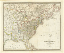
Important Dakota Territory Map, Annotated By George Henchel To Show The Yankton Route To The Black Hills Gold Rush
An important and extremely rare map of the Dakota Territory, including valuable annotations in manuscript by a Dakota pioneer, recording an expedition to establish a route from Yankton to the gold fields.
Originally printed by the U.S. Government for field use by high ranking officers and not intended for general distribution, the present map was almost certainly used (and extensively annotated) by Dakota Territory Deputy Surveyor General George Henchel, during a privately sponsored expedition from Yankton, D.T. to the Black Hills Gold Regions in early 1876.
As noted below, a significant portion of the annotations show daily route information by Henchel, locating the most practicable route from Yankton, the Territorial Capital of Dakota Territory, to the Black Hills.
Ludlow and Heap Map of Dakota Territory
The present map is and exceptionally rare government produced field map, intended for use by field officers, for the purpose of periodic updating and correction, and was not disseminated beyond this use in the West.
Compiled by Captain D. P. Heap and Captain William Ludlow of the Army Corps of Engineers and printed in St. Paul, Minnesota, the map represents the most detailed and authoritative mapping of the Dakota Territory published in the 1870s. The map depicts major topographical features, including towns, settlements and forts; newly-created Indian reservations, in particular those assigned to the Sioux by the 1868 Treaty of Fort Laramie.
The map is also a rich compendium of early exploration routes in the preceding decades. The map shows the progress of the route of the Northern Pacific to its temporary terminus at Bismarck, with alternative routes surveyed further west. It also includes the routes of over a dozen government expeditions, including Custer and Ludlow's momentous Black Hills Expedition of 1874. The General Land Office (GLO) surveys are shown along the west bank of Red River, the Sheyenne [sic] River, and the route of the Northern Pacific Railroad, as well as north of the Missouri, with progress through late 1873-early 1874.
The map also shows the location of the White Sone Hill Battle Field. On September 3, 1863, the Second Nebraska Cavalry, the Sixth Iowa Cavalry, and one company of the Seventh Iowa Cavalry, under the command of Brig. Gen. Alfred Sully, attacked a large Native American encampment in what is now south-central North Dakota. The location is referred to as the Whitestone Hill Battlefield, but in tribal memory it is the Whitestone Hill massacre site. The attack resulted in more Native casualties than any other conflict in North Dakota, with losses on a larger scale that those at Wounded Knee in 1890.
The first edition of the map was printed in February 1872 under the direction of Captain D.P. Heap, who shortly thereafter was re-assigned to duty in Charleston, South Carolina. Heap was succeeded by William Ludlow, who issued a significantly improved and updated March 1875 edition (the present map), with a final edition issued in 1878, which appears to now show a printed version of the route to the Black Hills set forth in pencil in our copy of the 1875 map, which named "Territorial Highway from the Black Hills to the Missouri," originating in the general vicinity of Rapid City (which is still not named on the 1878 edition of the map) and ending at the Missouri River, just south of Ft. Sully.
This remarkably detailed map was intended for use in the field at a highly fluid period of Dakota history, following shortly after the completion of the Black Hills Expedition, a United States Army expedition in 1874 led by Lieutenant Colonel George Armstrong Custer and Captain William Ludlow. The expedition set out on July 2, 1874 from Fort Abraham Lincoln, Dakota Territory, with orders to travel to the previously uncharted Black Hills of South Dakota, in order to locate suitable locations for a fort, find a route to the southwest, and to investigate the possibility of gold mining.
Arriving in the Black Hills on July 22, 1874, with orders to return by August 30. The expedition succeeded in establishing the existence of gold in the Black Hills. Custer wrote on August 15, 1874 to the Assistant Adjutant General of the Department of Dakota that "there is no doubt as to the existence of various metals throughout the hills." His messages were carried by scout Charley Reynolds to Fort Laramie, and from there it was telegraphed to the press eastwards.
The August 1874 discovery of Gold in the Black Hills sparked a Gold Rush into the Sioux reservation, whose boundaries were only inconsistently enforced by the U.S. Army, ultimately touching off the Great Sioux War of 1876-77.
It would appear that every effort was made to render the map as up to date as possible, with the inclusion of Custer and Ludlow's findings, the most recent work of the GLO, and no doubt other information.
William Ludlow (1843 - 1901) was an officer in the Corps of Engineers and a major general in the United States Army who served in the Civil War, Plains Indian Wars, the Spanish-American War, and led a scientific expedition examining the natural wonders of Yellowstone National Park. After the Civil War, Ludlow served in Charleston, South Carolina under Major Q.A. Gilmore until November 14, 1872, when he was re-assigned to serve as Chief Engineer of Dakota Territory, where he oversaw mapping and data collection of the 7th Cavalry's 1874 expedition into the Black Hills of what is now South Dakota.
David Porter Heap (1843 - 1910) was an army engineer officer attached to the 1871 Barlow party of Yellowstone explorers and co-author of the resulting official report. In February 1870, he was appointed chief engineer of the Department of Dakota, preceding Ludlow in this position. Heap's name also appears as the primary compiler of a Montana Territory map, published in 1872. By 1872, he had been relocated to Charleston, South Carolina, serving the Corps of Engineers and River and Harbor improvement projects in the Southeast, where he served as successor to William Ludlow, who was re-assigned to the west on November 14, 1872.
The map is one of several regional maps of the western United States prepared by the Bureau of Topographical Engineers before the Civil War and updated thereafter, most of which are now virtually unobtainable. Their rarity indicates that they were issued for use only by senior military officials and officers in the field and circulated in very limited numbers. This map of Dakota Territory is no exception. We were unable to locate any other examples of this second edition of the map, with OCLC recording two examples of the first edition (1872) and four of the third edition (1878).
Yankton Seeks Its Place In The Black Hills Gold Rush
In January 1876, following the first waive of gold seekers arrival to Dakota Territory, Yankton, D.T. sought to establish itself as the "nearest and most desirable route to the Black Hills." Following a meeting with territorial Governor John L. Pennington on January 25, 1876, a group of influential businessmen sought proposals for an expedition to establish the best route to the Gold Regions. A private exploratory expedition was organized by the town's business and political elite, in the hope that such a route, when combined with a planned rail link to Chicago, would make Yankton the most desirable gateway to the Black Hills. Experience elsewhere-at San Francisco, in particular-had demonstrated that by such means great fortunes could be made by those who "got in on the ground floor."
Seeking to lay claim to some of the economic benefits generated by this mass migration [to the gold fields], a number of western communities publicized themselves as the best starting and outfitting points for Black Hills-bound gold seekers….Yankton, the capital of Dakota Territory, sought to develop a combination rail-steamboat-overland stage network that it claimed to be the shortest and most advantageous route to the gold fields. (Anderson, "Wake Up, Yankton!," p. 211)
The first proposal came from Deputy US Marshal Henry C. Ash. A second proposal was made by George Henchel, the Deputy Surveyor of Dakota Territory, who proposed to pay $40 toward his own expenses. The two proposals were quickly combined into a single expeditionary force and the party set out on February 8, 1876 for the Black Hills, via Fort Randall and the Fort Thompson area.
Within the first week, during the stop at Fort Randall, George Henchel was issued two government odometers in order to obtain a precise record or the mileage travelled, further evidence of his role in the expedition and probable author of the annotations.
Annotations recording the Ash Black Hills expedition of 1876
The map bears a profusion of faint annotations in pencil, all probably in the same hand. One group records an unidentified journey south from Fort Seward (1872-1877) to Yankton between September 13 and 26. Each day's progress is shown, with "X"s mark camp sites and the location of "water in holes" indicated in several locations. Northwest of Fort Seward the writer has also sketched in a few additions to the township grid, while some arithmetical figures are sketched in the right margin of the lower sheet.
The most cohesive annotations extend from the Sioux Reservation on the Missouri River, crossing the Missouri River several times and extending to Fort Sully, before heading west toward the Black Hills. These annotations record the daily progress of the Ash 1876 expedition to the Black Hills gold fields. George Henchel, at the time Deputy Surveyor General of the Dakota Territory, kept a journal of the expedition, which was published in serial form in the Yankton Daily Press and Dakotaian on March 29 through April 1 of that year.
When examined together, this annotated map and Henchel's journal shed extraordinary light on this important expedition. While the map is not signed, given Henchel's occupation, the tools given to him at Fort Randall and his role as documentarian, it is highly likely that the annotations are in Henchel's hand.
After leaving Yankton, Ash & Co. followed the Missouri River northwest as far as Fort Pierre, from which point they headed west overland until they hit a trail laid by G.K. Warren in 1855. They followed Warren's route southwest for several days until turning more directly west at Sage Creek and on February 28 arrived at Rapid City, where they spent several days. Henchel mentions this in his journal:
February 27… we crossed Rapid creek… on arriving here, we found people (hardy looking men, black from the pine smudge and resembling the African race) busily engaged in the construction of buildings, and lots were offered us in the would-be town gratis… February 28… of course as well may be imagined, the starting of a town was discussed, and this was the general subject of all conversation. In the latter part of the day, steps towards organization of a board of town trustees was taken, and during a meeting in the evening… the new town was named Rapid City.
From Rapid City the group turned south, passing through Camp Crook, Hill City and a nearly-deserted Custer City, all of which are faintly marked on the map. From there they left the Black Hills and headed south, crossing the Cheyenne and White Rivers before turning east on March 9 to return to Yankton. After suffering mightily from harsh winter weather and running out of food, the first members of the group made it back to Yankton on March 24, 1876.
The manuscript annotations recording this journey begin at the oxbow of the Missouri upriver from Fort Thompson. The writer has indicated the route and the date, with "X"s to show where evening camps were made. Along the route are scattered other numerical annotations, somewhat indecipherable but likely indicating distances or times.
The most significant notes are in the Black Hills, where the newly-risen Rapid City as well as Camp Crook, Deadwood, Hill City and Custer City are penciled in. The notations on the return journey are more fragmentary-particularly after the eastward turn on March 10 at Spotted Tail Camp-but the general outline of the route can be discerned. The incompleteness of the annotations, the scrawled handwriting, and the worn folds in the map itself all suggest that Henchel recorded them in the field during the expedition.
The Territorial Highway
An interesting historical footnote to the map involves the so called "Territorial Highway." Multiple sources reference the Territorial Highway as "the route that Custer had taken to the [Black] Hills from Bismarck . . . " (Capace, Encyclopedia of North Dakota p. 109). However, it appears that this name was first used to describe the 1876 Black Hills Expedition route shown in manuscript on this map and later added in print on the 1878 edition of the Heap and Ludlow map of Dakota Territory, where it receives the name "Territorial Highway from the Black Hills to the Missouri."
Conclusion
While the route was one of several to the Gold Regions, the route from Fort Pierre would become the most popular wagon trail to the Black Hills, and an estimated 85 percent of all traffic destined for the Black Hills would come through Fort Pierre.
Setting forth the first depiction of the Fort Pierre route to the Black Hills, at the time of its first discovery by the original exploring party, the present map, an extraordinary rarity of early Dakota exploration, is made all the more valuable by Henchel's annotations.