|
||

|

|
|

|
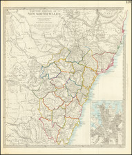
Colony of New South Wales and Australia Felix map, created by A.K. Johnston in 1844, delivers a richly detailed image of New South Wales and the area now known as Victoria. John Johnstone, W. & A. K. Johnston, James Lumsden & Son, and Rob Weir collaborated in publishing this map in Edinburgh and Glasgow during a pivotal time in Australian exploration.
The map uniquely documents the early exploratory routes of three key individuals before the transformative events of the gold rush. Major Mitchell's 1836 journey to the Darling and Murray Rivers unfolds along the red line, while the yellow line follows the surveying expedition of Mels Tyers & Townsend between Melbourne and the Glenelg River in 1840. Count Streletsky's 1840 exploration of the Australian Alps and Gipps Land traces the blue line.
"Fortunate Australia" or "happy Australia" translates from the Latin term "Australia Felix," which Major Mitchell used to describe the lush pastures he encountered on his 1836 expedition. The title "Australia Felix" would only persist for a few more years before it was renamed "Victoria" in 1851 after the region's separation from New South Wales.
Not only does this map provide invaluable geographical information, but it also narrates an early chapter of Australian exploration, settlement, and development into a thriving nation. With its distinctive piano key border and meticulous detail, it stands as a tribute to this region's historical evolution.
![[ New South Wales Electors in 1871 ] Map Shewing Roads & Postal Stations in New South Wales Prepared for the Use of the Post Office Department](https://storage.googleapis.com/raremaps/img/small/88237.jpg)