|
||

|

|
|

|
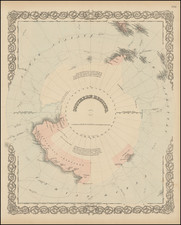
Scarce map of the Antarctic region, produced by the New Zealand Lands and Survey Department.
At the center of the map is the continent of Antarctica, shaded in a yellow tone, with large glacial ice barriers shown in blue.
The map employs an azimuthal equidistant projection, radiating outwards from the South Pole, which allows for the representation of all meridians as straight lines and all circles of latitude as circles, but distorts distance and shape as one moves away from the center.
The topography of Antarctica is outlined, with major geographical features such as mountain ranges and plateaus indicated, though detail is limited due to the scale and knowledge of the era. Notable locations within Antarctica are labeled, including the Ross Sea, the Weddell Sea, and various bays and peninsulas. The map also shows the surrounding bodies of water: the Southern Ocean, the Atlantic Ocean, and parts of the Pacific Ocean.
The map illustrates the lands claimed by several nations, including the Ross Dependency, Australian Antarctic Territory (2), Adelie Land and Falkland Islands Dependencies
Ross Dependency: This is a sector of Antarctica claimed by New Zealand. It is named after Sir James Clark Ross, who discovered the Ross Sea. The claim was formalized in 1923 and includes the area between 160 degrees east and 150 degrees west, south of 60 degrees south latitude. The Ross Dependency is directly south of New Zealand, and the historical significance lies in New Zealand's interest in the region for scientific research and exploration, especially following the International Geophysical Year (1957-1958).
Australian Antarctic Territory (2): The Australian Antarctic Territory is one of the largest territories in Antarctica, claimed by Australia. As of 1952, the claim covered nearly 6 million square kilometers and was initially proclaimed in 1933. The territory is divided into two parts: one extending west from 45 degrees east to 136 degrees east, and the other from 142 degrees east to 160 degrees east. Australia's interest in the region was driven by geographic proximity and the potential for scientific exploration and research, which increased after World War II.
Adelie Land (Terre Adélie): Claimed by France in 1924 and named after the wife of French explorer Jules Dumont d'Urville, Adelie Land lies between 136 degrees east and 142 degrees east. The claim was based on early French explorations and, by 1952, was significant for France's continuing scientific interests, marked by the establishment of permanent research stations such as Base Dumont d'Urville, which was set up in 1956.
Falkland Islands Dependencies: This was a British claim that included various territories in Antarctica and the South Atlantic, notably the South Sandwich Islands, South Shetland Islands, and the Graham Land on the Antarctic Peninsula. As of 1952, the historical significance of the Falkland Islands Dependencies was rooted in the UK's strategic and scientific interests in the region. Britain was one of the original signatories of the Antarctic Treaty, which came into force in 1961, and the claim's significance was highlighted by the Operation Tabarin during World War II and subsequent British expeditions and research stations established in the area.
By 1952, these claims had yet to be universally recognized, and the overlapping claims often led to complex geopolitical tensions. The Antarctic Treaty System, established later in 1959 and effective from 1961, would eventually set aside these claims for the sake of scientific cooperation and peace. The treaty prevents new claims and the expansion of existing claims in Antarctica, promoting the continent as a global commons dedicated to peace and science.