|
||

|

|
|

|
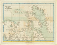
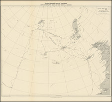
The First Printed Map To Illustrate RF Scott's Route To The South Pole
Detailed map illustrating the tracks of the British Antarctic Expedition of 1910-13, also known as the Terra Nova Expedition, led by Captain Robert Falcon Scott.
The expedition was a landmark event in the Heroic Age of Antarctic Exploration, primarily aimed at reaching the South Pole. The expedition is known for its tragic outcome, where Scott and his four companions perished on their return journey from the Pole.
The map shows a detailed route of the expedition's journey, marking various camps and key locations along the path. Notable geographic features and landmarks on the map include the Beardmore Glacier, a significant gateway to the Polar Plateau and one of the expedition's critical points. Other features like Mount Darwin, Mount Buckley, and various depots like the Upper Glacier Depot and the Lower Glacier Depot are marked, indicating supply points for the journey.
Scott's team set out from their base at Cape Evans on Ross Island and followed a route up the Beardmore Glacier, eventually reaching the Polar Plateau. The South Pole was ultimately reached on January 17, 1912, only to find that the Norwegian explorer Roald Amundsen had preceded them by approximately one month.
The members who reached the Pole along with Scott were Dr. Edward Wilson, Henry Bowers, Lawrence Oates, and Edgar Evans. Evans died near the foot of the Beardmore Glacier in February 1912, while Oates, suffering from frostbite and gangrene, walked out into a blizzard to his death in a self-sacrificial act, hoping to improve his companions' survival chances.
The remaining three, including Scott, perished from a combination of exhaustion, starvation, and extreme cold. Their bodies were found eight months later in their tent, along with their diaries and scientific observations, which provided a detailed account of their harrowing journey.
The map appeared in Scott's Last Expedition. Volume 1. Being the Journals of Captain R.F. Scott. Volume 2. Being the Reports of the Journeys and the Scientific Work undertaken by Dr. E.A. Wilson and the Surviving Members of the Expedition, published in London in 1913.
Edward Stanford (1827-1904) was a prominent British mapmaker and publisher. A native of Holborn in the heart of London, Edward was apprenticed to a printer and stationer at the age of 14. After his first master died, he worked with several others, including Trelawny W. Saunders of Charing Cross. Saunders oversaw young Edward’s early career, ensuring that he became a Fellow of the Royal Geographical Society. Associations with the Society eventually brought Sanders much business and gave him a reputation as a publisher of explorers. As testament to this reputation, the Stanford Range in British Columbia was named for him by John Palliser.
Stanford briefly partnered with Saunders in 1852 before striking out on his own in 1853. He was an agent for the Ordnance Survey, the Admiralty, the Geological Survey, the Trigonometrical Survey of India, and the India Office. He also controlled the maps of the Society for the Diffusion of Useful Knowledge, another lucrative source of income. In 1857, Stanford founded his namesake Geographical Establishment, with Saunders and A. K. Johnston as engravers. Thereafter, Stanford was known for his “library maps”, particularly those of Africa and Asia.
Addresses and Years of Operation:
- 6 Charing Cross, London (1848): Edward Stanford's initial place of employment at Trelawney Saunders' shop.
- 7 and 8 Charing Cross, London (1853): Stanford expanded his shop to these addresses.
- 55 Charing Cross, London (1873): The shop moved to this larger location.
- 12-14 Long Acre, London (1873): Site of the new print works and current flagship store.
- 7 Mercer Walk, London (2019): Stanfords moved to this address, continuing its legacy.
Stanford's work with Chief Cartographer John Bolton, including the 1858 Library Map of Europe, positioned the company as a leader in quality cartography during a time of exploration and colonialism. Their 1862 Library Map of London earned acclaim from the Royal Geographical Society. With the business thriving, Stanford purchased Staunton & Son in 1877 and, upon retiring in 1885, handed over the reins to his son, Edward Stanford II.
As sole agents for Ordnance Survey Maps, the company's influence and reputation grew, culminating in the Stanford’s London Atlas Of Universal Geography, which was presented to Queen Victoria in 1887. The transition into the 20th century saw further integration of retail, print, and cartographic operations at Long Acre.
During World War I, Stanford's became an essential publisher for the War Office. Edward Fraser Stanford took over in 1917, steering the company through the interwar period and innovations, such as the world’s smallest maps in 1922 and the Daily Mail Motor Road Map in 1926.
Withstanding a bombing in WWII, the company continued under the stewardship of John Keith Stanford and was sold to George Philip & Son in 1947. As it adapted to the digital age, Stanfords received the Ordnance Survey Premier Partner status in 2007 and ventured into online mapping and data services.
Stanfords, now an icon for travellers and explorers, has maintained its cultural relevance and retail success well into the 21st century, underpinned by a legacy of entrepreneurial spirit and commitment to cartographic excellence.
![[ Discovery of the Northwest Passage ] Chart Showing the Recent Search for a North-West Passage. Also the Coast Explored in Search of Sir John Franklin between the Years 1848 and 1854](https://storage.googleapis.com/raremaps/img/small/101874.jpg)