|
||

|

|
|

|
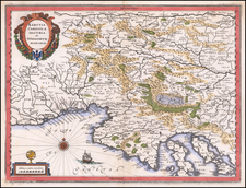
Finely engraved map of Italy, published by De Bry for J. J. Boissard's Romanae Urbis Topographiae & Antiquitatum" translates roughly to "The Topography and Antiquities of the Roman City.
Theodor De Bry (1528-1598) was a notable Flemish engraver and publisher. The present map was prepared to illustrate Broisard's boo on the topography and ancient ruins of Rome.
The map details the geographical landscape of Italy, Corsica, Sardinia and Sicily, showcasing the topography of its regions, cities, towns, and important landmarks. The details are based upon contemporary late 16th century information. The map includes a "Miliaria Italica communia", showing distance in common Italian miles.
The numerous ships depicted on the map reflect Italy's maritime prominence and significance during this period. The inclusion of ships not only served an aesthetic purpose but also highlighted the importance of sea routes and navigation in the Mediterranean. The presence of a sea creature is quite typical for maps from this era. These mythical or exaggerated creatures, often seen in the margins or the waters surrounding landmasses, added an element of wonder and intrigue. They also mirrored contemporary beliefs or tales about the mysteries of the uncharted waters.
Rarity
The map is very rare on the market. This is the first example we have seen.
Theodor de Bry (1528-1598) was a prominent Flemish engraver and publisher best known for his engravings of the New World. Born in Liege, de Bry hailed from the portion of Flanders then controlled by Spain. The de Brys were a family of jewelers and engravers, and young Theodor was trained in those artisanal trades.
As a Lutheran, however, his life and livelihood were threatened when the Spanish Inquisition cracked down on non-Catholics. De Bry was banished and his goods seized in 1570. He fled to Strasbourg, where he studied under the Huguenot engraver Etienne Delaune. He also traveled to Antwerp, London, and Frankfurt, where he settled with his family.
In 1590, de Bry began to publish his Les Grands Voyages, which would eventually stretch to thirty volumes released by de Bry and his two sons. The volumes contained not only important engraved images of the New World, the first many had seen of the geographic novelties, but also several important maps. He also published a collection focused on India Orientalis. Les Grands Voyages was published in German, Latin, French, and English, extending de Bry’s fame and his view of the New World.
![L'Italia e i suoi principali prodotti [Italy and her Principal Products]](https://storage.googleapis.com/raremaps/img/small/89640.jpg)
![Plan Des [Ersten?] und Lezten Theil Der Affeire Des Feldmarschal Konigseg in Tyrol](https://storage.googleapis.com/raremaps/img/small/51959.jpg)