|
||

|

|
|

|
Stock# 89640
Description
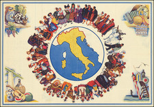
Very interesting mid-20th-century pictorial map of Italy, dividing the country into regions with each area's economic outputs shown.
The map shows grain and other farm products in Italy's more agricultural south, while the north has a greater industrial focus. Fishing is shown in the Mediterranean. A decorative compass rose appears in the lower left.
This map was produced by the "La Scuole" editors located in Brescia, Italy.
Condition Description
Old fold lines and foxing.
![[World] Air France --](https://storage.googleapis.com/raremaps/img/small/93647.jpg)
![Camp Pendleton [cover:] Two Weeks With The Marines in California](https://storage.googleapis.com/raremaps/img/small/92525.jpg)