
![[Bahamas] Isles Lucayes By Alain Manesson Mallet](https://storage.googleapis.com/raremaps/img/small/96723.jpg)


|
||

|

|
|

|
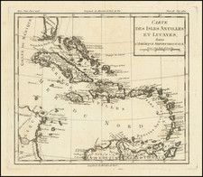
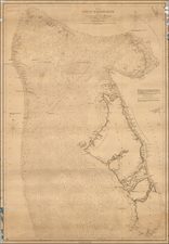
Decorative map of the Bahamas, a portion of the east coast of Forida and central Cuba, with a marvelous battle scene in the background.
The map, while modest in size, displays a precise arrangement of the islands. It features the eastern coastline of Florida on the right and a minor portion of Cuba below, but its main focus remains the Bahama Islands. The uncluttered simplicity lends the map an austere elegance, allowing the geography of the region to speak for itself.
In the top of the map is a dramatic naval battle scene. Around ten sailing ships are shown, with smoke billowing from the cannons, indicated by simple, wispy lines, is a striking feature that adds a visual narrative to this otherwise unembellished map.
The simplicity and modesty of the map contrast with the turbulent history of the Bahama Islands in the 17th century. As the Bahamas lies in close proximity to the frequently contested territories of Florida and Cuba, it often found itself as a refuge for pirates and a place of conflict among European powers.
The 17th century was a period of significant change for the Bahamas. European colonization in the region, led by the English, began around the mid-17th century. However, these early settlements faced various challenges including conflicts with the native Lucayans, limited resources, and frequent pirate attacks.
The naval battle depicted on the map is a stark reminder of the violent confrontations between different colonial powers, often British, French, and Spanish, as they sought control over the strategically placed islands. This was a time of the buccaneers, with the infamous pirate Blackbeard using the islands as his base of operations for some time.
By the end of the 17th century, the archipelago was virtually uninhabited due to frequent invasions, pirate activities, and struggles between colonial powers. It wasn't until the 18th century that the Bahamas saw an era of relative peace and development, with the introduction of plantation economies and an increase in trade and population.
From Mallet's monumental Description de l' Univers, first published in Paris in 1683, perhaps the greatest work of its kind in the 17th Century.
Alain Mannesson Mallet (1630-1706) was a French mapmaker and engineer who served in the armies of Louis XIV. After rising through the ranks, Mallet was appointed as Inspector of Fortifications, a job which also required mathematical skills and which made him a competent military engineer. Eventually, he joined the court of Louis XIV at Versailles, where he taught math and focused on writing.
Mallet is best known for his Description de L’Univers, first published in 1683, in five volumes. A wide-ranging geographical work, the Description included textual descriptions of the countries of the world, as well as maps of the celestial sky and the ancient and modern worlds. The Description continued to be published until the early eighteenth century. He also published a work in three volumes on warfare (1684) and a primer on geometry (1702).
![Island of Cuba (Spanish) and Jamaica (British) [also South Florida, Bahamas and Cayman Islands]](https://storage.googleapis.com/raremaps/img/small/98323.jpg)