|
||

|

|
|

|
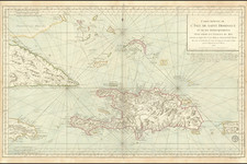
Stock# 90694
Description
Detailed chart of a the southeastern Bahamas, eastern Cuba and the northeastern part of Hispaniola, published by the U.S. Navy Hydrographical Office.
Includes soundings, sailing directions, light house information and other important sailing details.
The map has been circled to locate the major light houses on the chart.
Condition Description
Minor soiling.
![F.C. de Samana y Santiago. Sanchez [Santa Domingo]](https://storage.googleapis.com/raremaps/img/small/87648.jpg)
![Porto Rico and Virgin Islands [with] Haiti, Hispaniola or St. Domingo](https://storage.googleapis.com/raremaps/img/small/78402.jpg)