|
||

|

|
|

|
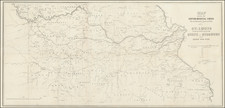
Porter's Groundbreaking Map of the Human Geography of the Mississippi.
The Homo-Graphic Chart of the Settlements on the Mississippi River, compiled by General Thomas Jefferson Porter and engraved by Doolittle and Munson and Thomas Twichel in Cincinnati in 1842, provides an exceptional mid-19th-century picture of the Mississippi, stretching from Cairo at the confluence of the Ohio River to New Orleans. This chart, presented in four parallel columns, offers a granular human geography of the river, delineating its role in the burgeoning system of plantation agriculture and slavery along its southern contours. The map systematically marks the names of land owners, distinguishes between whites and blacks in population data, and punctuates economic details like cotton bale production for specific counties.
The 1840s marked a pivotal moment for the American South, especially the Mississippi River region. It was a period of intense economic activity, characterized by a reliance on slave labor for cotton cultivation, making the river a commercial artery for the plantation economy. This chart embodies an innovative thematic representation, displaying information about plantation locations, population distribution, and local economies, not just topographical details.
While the Homo-Graphic Chart may have drawn inspiration from previous works like Philip Pittman's The Present State of the European Settlements on the Missisippi, its distinct thematic approach made it a pioneering effort. Later influential works, such as Marie Adrien Persac's 1858 Chart of the Lower Mississippi River, J.T. Lloyd's 1862 Map of the Lower Mississippi River, and Colony & Fairchild's 1866 Ribbon Map of the Father of Waters, can trace their lineage to Porter's innovation.
The extensive catalog entry from the 1917 American Art Association "Nuggets of American History" sale describes the map thusly:
Of excessive rarity... This is the earliest and perhaps only map of its kind... The names of over 3000 residents, whose dwelling places adjoin the banks of the river along the 1042 miles of its course, and also the names of those residents whose houses are close to some inland body of water, are given. Among these names is one of a colored man, no longer a slave, free Bob. Most of the names are individualized, as--Genl., Maj., Col., Capt., Honbl., Revd., Doct., Judge, Sqr., Postmaster, all of which are followed by the full name of the resident. The names of women who own property, are shown, either with their Christian name or as Mrs. or Miss. Among others mentioned are owners of stores and saw-mills and one Ed Cherry, Negro, Outlaw, Blue foot Hill, Negro, etc.
Contemporary Discussion
The Southron, 2 Aug 1843, Wednesday, Page 2 (Jackson, Mississippi):
HOMO-GRAPHIC CHART.
We are pleased to have it in our power to State that these very useful charts of Gen. T. J. Porter have arrived and can be had at the Drug Stores of the Messrs. Green. The Homo-Graphic Chart gives an accurate view of the Mississippi River from the mouth of the Ohio to New Orleans, embracing all the statistical information possible to be condensed into so small a compass. The names of the residences, plantations, &c., of every individual on the banks of the Mississippi are accurately located. To persons travelling on our western waters or to those who have an interest in this part of the Mississippi Valley, this chart will be of the first importance. Gen. Porter has devoted much time and labor to the production of just such a work as was greatly needed, and we feel sure his labors will be amply rewarded. A pocket chart of the same kind, but a size smaller, has been made for the especial benefit of the travelling world. We invite the attention of the public to this chart at Green's Drug Stores.
The Guardian, 15 May 1844, Wednesday (Columbia, Tennessee):
HOMO-GRAPHIC CHART of the Settlements on the Mississippi River. By THOMAS J. PORTER.
This beautifully executed Chart is of equal interest and utility. It is the production of a Tennessean, lately deceased, whose unrivalled business talents, combined with a high personal character, gave promise,--alas for the uncertainty of earthly hopes!--of a long life, honourable to himself and useful to his country.
The Chart exhibits the settlements, etc, on the river, from Cairo, at the mouth of the Ohio, to New-Orleans, a distance of one thousand and forty miles. This length is arranged in four sections, of about three feet each--a scale sufficiently large to admit the insertion of the names of all the planters, even where "the coast" is most thickly studded with estates. Opposite to the most remarkable places along the river, there are figures that show the distance of each from Cairo. A good deal of information on the hydrography of the Mississippi is also given, the principal sand-bars being marked and the Islands numbered or named. All together, it embodies a mass of information relative to one of the most interesting and important rivers in the world, such as must be sought for in vain from any other source. The work is, withal, executed in a style of great elegance; the lettering in particular, is done with the utmost distinctness.
We are free to confess that an examination of this beautiful Chart has very much interested us. It presents the population, the enterprise, and the inexhaustible wealth of the Mississippi, in a point of view so striking as to arrest the attention and excite the interest of every one at all accustomed to take enlarged views of things...
Rarity
The map is very rare. OCLC locates two examples only, at the University of Alabama and Harvard. To this, we can add an example at Tulane University.
Earlier press accounts indicate a few other possible institutional examples. In 1917, St. Louis University is recorded as having paid $50 "for the rare homo-graphic chart of the settlements of the Mississippi, printed at Cincinnati in 1842." Evidently, New York Historical Society received an example of the map in 1843, according to a contemporary account.
There is mention of a smaller pocket version of the map in one contemporary description, however, we cannot confirm that.
The last example we trace in the antiquarian market was offered for sale in 1926, in C. F. LIBBIE & CO. Catalogue No. 969.
General Thomas J. Porter (1805 - August 30, 1843) was a prominent figure born in Maury Co, Tennessee, and later associated with Victoria, Bolivar County, Mississippi. On July 22, 1837, he married Mary Ann Crouse in Sugar Grove, near Chillicothe, Ohio. The exact origins of his title "General" remain uncertain, though it seems he was associated with the State Militia in Tennessee in the 1830s. General Porter's reputation was one of honor, being praised posthumously as an epitome of integrity and nobility. As described by the Memphis Enquirer, he stood as an embodiment of an "honest, true-hearted gentleman," fulfilling various roles as a dedicated citizen, a devoted husband, and a loving father. Tragically, in August of 1843, Mary and Thomas's son fell sick and died. Then Thomas himself contracted a fever and died in Memphis, Tennessee. His death was deeply mourned by his community and fellow members of the Masonic Fraternity, where he was revered as a valued member. Notably, he was embroiled in controversy when he was purportedly implicated in a bank robbery in Tennessee, a claim that garnered significant attention in the local press, with a plethora of character witnesses professing his innocence to local newspapers. Porter's most enduring legacy was his groundbreaking 1842 Homo-Graphic Chart of the Settlements on the Mississippi River, the greatest map of the human geography of the Mississippi made up to that time.
![[ Oil & Gas in Texas and Louisiana ] Gulf Coastal Region Texas and Louisiana Showing Oil, Gas & Sulphur Fields & Prospects Pipe Lines & Refineries](https://storage.googleapis.com/raremaps/img/small/101409.jpg)