|
||

|

|
|

|
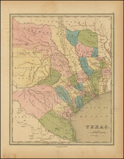
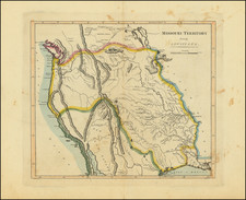
Mapping The Oil & Gas Infrastructure of Texas & Louisiana
Large detailed overview map of the oil, gas and Sulphur Fields (producing and under exploration) as well as the pipe lines and refineries in Texas and Louisiana in 1938.
This large map provides a fine overview of the early 20th-century oil industry in the United States, specifically detailing the then-current and potential areas for oil, gas, and sulphur extraction along the Gulf Coast. Prepared by The Oil Weekly in collaboration with Gulf Coast Engineering Co., Houston, Texas, the map offers an intricate overview of the resource-rich terrains of Texas and Louisiana, marked meticulously to reflect oil fields, gas production sites, sulphur prospects, pipelines, and refineries as of the year 1938.
In 1938, the American oil industry was in the midst of an era of industrial expansion and the burgeoning significance of petroleum products in both domestic and industrial sectors. Texas and Louisiana stood at the heart of America's energy sector, with the Gulf Coastal region identified as a primary source for oil and gas reserves. This period was crucial for energy development in the U.S., setting a foundation for future economic growth and technological advancements. The map offers both a geographical and industrial snapshot and historical record of exploration and exploitation activities on the eve of World War II, when American energy production would be championed as a major asset and propaganda tool buoying the spirits of its Allies.
The map is expansive, covering the Gulf Coastal regions of Texas and Louisiana, delineated with remarkable precision. It categorizes oil fields with symbols, distinguishing between 'Salt Dome Type', 'Probable Deep Salt Dome', and 'Structures Other Than Regular Salt Dome'. Additionally, it represents 'Other Fields' with unique identifiers for 'Sulphur Production on Salt Dome', 'Gas Production', and 'Oil & Gas Production'. The legend is meticulous, facilitating an understanding of the geographic distribution of energy resources.
The map also meticulously plots infrastructure critical to the oil and gas industry, including oil and gas pipe lines, marked by distinct styles of lines for clarity, as well as locations of refineries and gasoline plants, crucial for transforming raw resources into usable products. The symbols are standardized across the map, with additional textual information providing specifics on the type of production and prospects, which include 'Oil Field Prospects (Geological or Geophysical)', 'Known Salt Dome', 'Salt Dome Type Prospect', and 'Prospect Other Than Salt Dome Type'.
The delineation of pipelines and refineries alongside natural resources underscores the intertwined nature of geography and industrial development, highlighting the early stages of infrastructural expansion that would define the global energy market during World War II.