|
||

|

|
|

|
Stock# 95163
Description
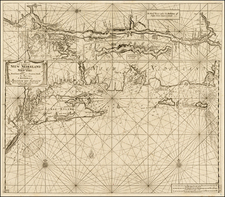
Early Map of the Northeastern United States and Canada in the 18th Century
Finely detailed map of the Northeast extending from Philadelphia up the coast to Ile d'Anticosti and the mouth of the St. Laurence, published in Paris, shortly after the French Revolution.
Extends inland to show part of Lake Ontario with fine detail along the Hudson River. Locates scores of towns and villages, shows roads, mountains and watershed.
Four distance scales.
Reference
McCorkle 797.5