|
||

|

|
|

|
Previously Unrecorded State.
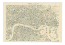
A Plan of London, with its Modern Improvements, engraved by Samuel John Neele and published by Richard Phillips in London in 1812, is a significant cartographic representation of the city. Extending to Hyde Park and Paddington in the west and Stepney in the east, the City of London itself is distinctly outlined in red. First produced in 1803, the map reflects the state of London in the early 19th century, highlighting its continuous expansion and the modern improvements of the time.
During the early 1800s, London was undergoing a profound transformation. The beginning of the Industrial Revolution, the growth of the British Empire, and the city's emerging status as a global financial center marked this era. These changes were accompanied by urban expansion and infrastructure developments, all of which are evident in this map. The red outline of the City of London symbolizes the heart of the historical and financial district, distinguishing it from the growing metropolis surrounding it.
The map's engraving, undertaken by Samuel John Neele, is an example of the artistry and precision that characterized cartographic work of this period. It represents not just geographical features, but also architectural and urban planning innovations that were part of London's "modern improvements." The inclusion of areas like Hyde Park and Paddington illustrates the growing importance of public spaces and suburban expansion, reflecting the broader social and cultural changes occurring within the city.
A Plan of London, with its Modern Improvements is more than a map; it is a snapshot of London at a pivotal moment in its history. By capturing the city's transformation and growth, it serves as a tangible link to a period of dynamism and change. The map's particular focus on the differentiation between the historic City of London and the expanding metropolis provides insights into urban planning, architectural trends, and societal evolution. This, combined with its aesthetic execution, makes it an invaluable resource for understanding the complexity and vibrancy of early 19th-century London.
States
Howgego (229) records four states, the final of which with the date in the imprint advanced to 'May 1.st 1808'. Samuel John Neele's signature has been erased from that state.
On our map, the imprint now reads "Published May 1st 1812 by Richd. Phillips New Bridge St."
![[ London ] Londinum Feracis: Ang. Met.](https://storage.googleapis.com/raremaps/img/small/74642.jpg)
![Bartholomew's Plan of London [London Fire Brigade Instructional Map]](https://storage.googleapis.com/raremaps/img/small/72233.jpg)