|
||

|

|
|

|
Stock# 72233
Description
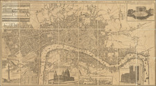
Exceptionally detailed large format map of London from the beginning of the 20th century.
The map was published by prolific Edinburgh mapmaker John Bartholomew, presumably sometime around 1939, given the hand-written date in the upper-left corner.
The map was evidently used to train fire brigades in navigating the city, which is famously difficult.
Almost all streets are named. Major public buildings are illustrated. Postal codes are delineated.
Condition Description
Very large folding map dissected and mounted on original linen folding into red leatherette case title "London Fire Brigade Instructional Map". Some scattered stains, as illustrated.
![[ London ] A New and Correct Plan of the Cities and Suburbs of London & Westminster Borough of Southwark with the Country adjacent the New Buildings Roads](https://storage.googleapis.com/raremaps/img/small/102623.jpg)
![[Suburbs of London] Sheet 1: Bayswater, Notting Hill, Kensal Green, Shepherds Bush &c. [with] Sheet 2: Greenwich &c. [and] Sheet 3: Bromley, Blackwall &c.](https://storage.googleapis.com/raremaps/img/small/80967.jpg)