|
||

|

|
|

|
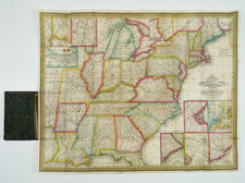
Mapa Geografico que Comprehende la Nueva Inglaterra, Nueva York, Nueva Jersey, Pensilvania, Maryland y Parte de Virginia, is a rare Spanish map of the United States, created by Tomas Lopez and published in Madrid in 1778. Unusually, this map portrays areas outside of those historically colonized by Spain, making it an atypical representation in the realm of Spanish cartography. It was issued in the midst of the American Revolution, capturing a pivotal moment in North American history and providing a Spanish perspective on the unfolding geopolitical landscape.
The map showcases the region extending from southern Maine to the Chesapeake, and westward to incorporate a portion of Lake Erie. It denotes New York along the Hudson River, with a vast area of upstate New York labeled as "Iroqueses," reflecting the territory's Native American inhabitants. Forts dot the landscape to the south of Lake Champlain, including Fort Miller, Edward, Hardy, and Hunter, embodying the military tensions and fortifications of the Revolutionary era.
Lopez credits the works of Evans, Mitchell, Jeffreys, and d'Anville, and as such the map marks a convergence of geographical perspectives, consolidating diverse sources of cartographic information. It uniquely sets its longitude from El Hierro, the southernmost of the Canary Islands, a characteristic departure from common British and French standards that usually set longitude from London or Paris.
The address provided, "en Madrid, en la calle de las Carretas, entrando por la Plazuela del Angel," suggests the broader dissemination and commercial reach of Tomas Lopez's works. This map, with its unique perspective, impressive geographical scope, and relevance to a momentous period in American history, embodies a crucial facet of 18th-century cartography, and significantly contributes to our understanding of the diverse perspectives on the American Revolution.
Tomás López de Vargas Machuca (1730-1802) was one of Spain’s most prominent cartographers in the eighteenth century. He was born in Toledo but studied at the Colegio Imperial in Madrid, where he focused on mathematics, grammar, and rhetoric. Along with a small group of colleagues, in 1752 the Spanish government sent López for training in Paris with the renowned geographer Jean Baptiste Bourguignon d’Anville. When he returned to Spain he was named Geógrafo de los dominios de Su Magestad and put in charge of the geographic collections of Charles III. He published many maps, including his fascinating maps of the Americas, and a variety of geography manuals. Some of his most famous maps are of the Iberian Peninsula, part of his large project to create a majestic atlas of Spain. Unfinished in his lifetime, López's children published the Atlas Geográfico de España (Geographical Atlas of Spain) in 1804. It was republished in 1810 and 1830.
![[Long Island Sound from Hampstead Bay to Huntington Bay]](https://storage.googleapis.com/raremaps/img/small/51310.jpg)