|
||

|

|
|

|
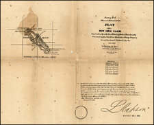
One of the Earliest Obtainable Maps of Santa Barbara.
Preliminary Sketch of Santa Barbara, California, is a rare and historically significant coastal survey map from 1853. Conceived under the supervision of Superintendent A.D. Bache, the sketch offers an invaluable early depiction of Santa Barbara, encompassing roads, rivers, mountains, and the architectural remnants of the area's mission-era past.
Emerging from the United States Coast Survey—an initiative originally backed by Thomas Jefferson—the detailed topography was crafted by A.M. Harrison and the hydrographic details were furnished by a team led by Lieutenant James Alden. This represents a crucial period in U.S. history, as it was during the 1840s and 1850s when the organization began to map the American coast in earnest. The map thus stands as a testament to the growing scientific and geographical prowess of the U.S. during the mid-nineteenth century.
Furthermore, the map offers an engaging glimpse into Santa Barbara's early urban and natural landscape. With its explicit delineation of the town's layout, geographical features such as mountains and rivers, and locations like the "Mission and Ruined Village," this map embodies the spirit of the era, characterized by exploration and documentation. The map's inclusion of a "View of the Town and Mission of Santa Barbara" enhances its value by providing a visual context to the surveyed geographical data.
As one of the first obtainable maps of Santa Barbara, it forms a remarkable window into the city's past.
Variant
This example is a rare thick-paper presentation variant—a prestigious edition intended for specific recipients under the authority of the Congress and the Treasury Department. This not only signals its historical importance but also underscores the high regard in which such charts were held by contemporary institutions.
The United States Office of the Coast Survey began in 1807, when Thomas Jefferson founded the Survey of the Coast. However, the fledgling office was plagued by the War of 1812 and disagreements over whether it should be civilian or military controlled. The entity was re-founded in 1832 with Ferdinand Rudolph Hassler as its superintendent. Although a civilian agency, many military officers served the office; army officers tended to perform the topographic surveys, while naval officers conducted the hydrographic work.
The Survey’s history was greatly affected by larger events in American history. During the Civil War, while the agency was led by Alexander Dallas Bache (Benjamin Franklin’s grandson), the Survey provided the Union army with charts. Survey personnel accompanied blockading squadrons in the field, making new charts in the process.
After the Civil War, as the country was settled, the Coast Survey sent parties to make new maps, employing scientists and naturalists like John Muir and Louis Agassiz in the process. By 1926, the Survey expanded their purview further to include aeronautical charts. During the Great Depression, the Coast Survey employed over 10,000 people and in the Second World War the office oversaw the production of 100 million maps for the Allies. Since 1970, the Coastal and Geodetic Survey has formed part of the National Oceanic and Atmospheric Administration (NOAA) and it is still producing navigational products and services today.