|
||

|

|
|

|
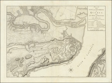
Detailed battle map of the region around Manhattan and New York City.
The map shows Brookland (Brooklyn), Flatbush, Gravesend, New Utrecht, Gowen's Cover, Flatland, Flushing, New Town, Whiston, West Chester, Frogs Neck, East Chester, Bloomingdale, King's Bridge, Fort Independence, Spiking Devil, Jeffery Hook, Cheveux de Friese, Fort Washington, Haerlem, Morrisania, Turtle Bay, Kep's Bay, Robt Murray's House Bergen, Brookland Ferry, Red Hook, Hobock, Redoubt and Bushwick Inlet, Horen's Brook, Dykeman's Bridge, and other place names.
Several Battle Plan details, including the March of the Troops under Gen'l Clinton, the Road to Jamaica, the point where Gen'l Grant engaged Ld. Stirling, etc. Numerous roads are also shown. A fine example, in attractive color. The map appeared in Dr. Gordon's History of the American War, one of the best contemporary British Accounts of the Revolution.
![[Hells Kitchen / Midtown West] Map of the Hermitage Farm and the Norton Estate Compiled From Authentic Data.](https://storage.googleapis.com/raremaps/img/small/61035.jpg)
![(New York City) [Original portrait of an American gentleman with New York City Street Plan]](https://storage.googleapis.com/raremaps/img/small/84607.jpg)