|
||

|

|
|

|
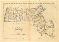
D.F. Robinson's school atlas map of the New England states stands out for its simplicity and clarity. Covering Connecticut, Rhode Island, Massachusetts, New Hampshire, Vermont, and the southern part of Maine, Robinson's map is distinctly tailored for educational purposes.
Each state is differentiated using distinct colors, making it easy for the viewer to identify and understand the geographical relationships between them. Within these state boundaries, the map further delineates each county, providing a clear understanding of the administrative divisions within.
Robinson's decision to highlight county seats emphasizes the importance of certain towns from an administrative standpoint. This becomes a useful reference point, especially when paired with the symbol system used to represent the population of major towns. Instead of inundating the map with numbers, symbols offer a quick visual cue on population density and distribution.
Beyond administrative and demographic details, Robinson's map also showcases the region's natural geography. Rivers, lakes, and islands are clearly marked, offering students a comprehensive view of the region's landscape. These natural features not only enhance the map's visual appeal but also provide context for understanding the settlements and population centers in relation to the natural geography.

![Carte Reduite Des Costes Orientales De L'Amerique Septentrionale . . . contenant L'Isle Royale . . . La Nouvelle Angleterre et la Nouvelle Yorc . . . MDCCLVII [with Plan of Boston Harbor] Plan du Havre de Baston](https://storage.googleapis.com/raremaps/img/small/80006.jpg)