


|
||

|

|
|

|
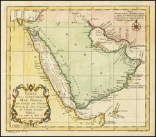
In the exceptional mid-19th century map, Arabia. Egypt, Abyssinia &c., George Philip offers a meticulous geographical account of the Arabian Peninsula and the Horn of Africa. Published in Liverpool in 1855, this map constitutes a comprehensive snapshot of the regions during an era of significant exploration and political transformation.
As the 19th century marked a period of intense European exploration and colonial expansion, this map by George Philip is a product of those ventures. His mapping of the Arabian Peninsula and the Horn of Africa captures the confluence of cultures, trade routes, and strategic interests that defined the region at the time. The intricate labeling and careful cartographic detail illustrate, among others, the regions of modern-day United Arab Emirates and Qatar in their historical context, providing a glimpse into the geopolitical landscape of the period.
Notably, the map's depiction of the Persian Gulf and the present-day United Arab Emirates is of considerable interest. Locations such as East India Cos. Is., Abothubbee (Abu Dhabi), Ras Zubbaya, and Seir Aboueid are marked, while in present-day Qatar, landmarks like Ras Reccan, Affeerat, Zabara, and Ras Boogmaies are labeled. The labeling of Bahrein I. further underscores the strategic and commercial importance of these areas during the 19th century.
The cartographic precision, combined with historical and geographic relevance, makes Arabia. Egypt, Abyssinia &c. an invaluable document of mid-19th century mapping practices. It allows modern viewers to trace historical shifts in boundaries, political divisions, and cultural landscapes, providing a fascinating perspective on these regions' past that is as enlightening as it is intriguing.
![[ Arabia ] Carte Des Trois Arabies Tiree en Partie de l'Arabe de Nubie, en partie de divers autres Autheurs . . . 1654](https://storage.googleapis.com/raremaps/img/small/99810.jpg)
![[ The Monarchy of Alexander the Great ]](https://storage.googleapis.com/raremaps/img/small/98737.jpg)
![[English Language Edition!] Natoliae Quae Olim Asia Minor Nova Descriptio [with] Aegypti Recentior Descriptio [with] Carthageinis Celeberrimi Sinus Typus [shows Cyprus]](https://storage.googleapis.com/raremaps/img/small/78508.jpg)
![[ French Sudan ] Colonie du Soudan Francais - Carte Routiere dressee au Service Geographique de l'A.O.F. a Dakar, d'apres les renseignements fournis par le Gouvernement du Soudan, ainsi que les leves et itineraires des Offers. et Sous-Offers. du Service Geographique . . . 1927](https://storage.googleapis.com/raremaps/img/small/100560.jpg)