|
||

|

|
|

|
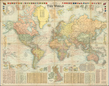
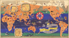
Johnstons' 1862 Wall Map of the World: A Glimpse into the Pinnacle of 19th Century Cartography
At the height of the British Empire in the 19th century, this ambitious map by the Johnston mapmaking firm stands as a testament to the meticulous craft the era. This 1862 wall map does more than merely depict territories; it encapsulates the pulse of the global commercial world and the intricate web of international connections.
With the British Empire in red, the map provides a marvelous snapshot of the world shortly after the discovery of the Northwest Passage and at a time when the Antarctic regions were just coming into focus after the initial discoveries of the late 1830s and early 1840s.
Prepared on Mercator's Projection, the map offers a nod to its navigational utility. Invented by Gerardus Mercator in 1569, this projection was favored by navigators and sailors because it represented lines of constant course, known as rhumb lines, as straight segments.
A standout feature is the map's focus on places of commercial importance. It meticulously positions every significant commercial location, thus serving as an invaluable tool for merchants, businessmen and the educated classes of the time. Not only does it show territories, but it also dives deep into the heart of the oceans, detailing the principal currents, including their direction and rate of progress. These details, particularly the velocity annotations in nautical miles over 24 hours, would have been essential for an general understanding navigational planning and marine logistics.
Further enhancing its utility is the enlarged map of Central Europe. The emphasis here is on the burgeoning world of railways. By highlighting railway communication between European countries, it offers insights into the transportation revolution that was reshaping the continent. The distinction of states within the German Customs Union is also significant, indicating major economic zones of the time.
Tables embedded within the map offer further details. Distances between principal ports, using conventional sea routes, provide immediate reference for sea voyages. The overland route to India, a key colonial artery, is a testament to Britain's expansive empire and the importance of India within it. Speaking of the British Empire, the map provides information on British colonies, including population statistics and acquisition dates – a concise representation of the empire's global reach.
Lastly, the specific emphasis on distances from London on usual sea routes places London at the center of this global web, reiterating its position as the heart of commerce, navigation, and empire during this era.
Rarity and States of the Map
The map was likely published as early as about 1855 and was still being published in 1887, although all states seem to be very rare.
![[World -- Terrestrial Globe Gores]](https://storage.googleapis.com/raremaps/img/small/89195.jpg)