


|
||

|

|
|

|
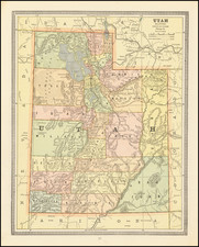
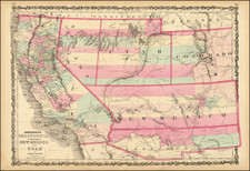
Rare First State of Johnson's map of the Southwest
Johnson & Browning's map of the Southwest, issued from 1860 to about 1887, provides a unique template for observing the evolution of the Transmississippi West through the eyes of a single publisher. Known in approximately 25 different states of the map, Johnson's map allows the view to track the evolution of western territories and their changing boundaries and the birth of western counties on a single canvas.
First State of the Map
The first state of the map provides a remarkable snapshot of the west:
- Nevada: While not named in the title, Nevada has recently become a territory, at the beginning of the mining boom in the area here labled as Carson Valley. Bigler Lake, the future LakeTahoe, is entirely in Nevada and the only towns named are Genoa on Bigler Lake and a Mormon Settlement.
- Utah: Most of its counties are still shown stretched across what is now Nevada. The border between Utah and Nevada is 2 degrees west of its present border, which was moved on several occasions between 1860 and 1864, a function of anti-Mormon sentiments in Congress.
- New Mexico Territory is shown extending from California to Texas, with Arizona Territory shown below New Mexico Territory. This configuration, which found its routes as early as the mid-1850s, reflects Johnson's keen awareness of impending Territorial changes, although in this instance, incorrectly so. However, Arizona would remain below New Mexico for several early states of Johnson's map.
Over the course of the next 3 decades, Johnson's maps would evolve on nearly an annual basis. A comprehensive collection of maps of the American West is incomplete without a good run of these maps.
States
Ira Johnson has identified two separate lithographic stones, which were used between 1860 and 1887, including 8 states of the first stone (1860-1864) and 17 states of the second stone (1864-1887).
The present map is Ira Lourie's State 1.0 (first plate, first state), which he dates to 1860 with the following note from Ira Lourie's Johnson Mapping Project:
Page 47-48. AZ & NM above each other; NV boundary extends in the north west from about longitude 113 to 120 then due S to Mormon Settlement then SE to southern border which is the same as UT’s.
The first state can be differentiated from the next two states as follows:
- 2.0 - 1860-1861: Page 54-55. No other changes.
- 3.0 - 1861-1862: Page 54-55. The names "UTAH" and "NEVADA" no longer overlap; NV boundary now extends in the north west from longitude 116 past 120 to the eastern edge of Goose Lake then due south to Beckwith Pass then south along the Sierra Nevada Mountains to southern border which is the same as UT’s; also CO defined out of UT, KS, NE.
Early Proposals For The Creation of Arizona Territory - The Baylor Line
In the 19th century, the American West was rapidly changing. Not only was it a frontier of new settlements and opportunities, but it was also a canvas on which state lines and territories were being redrawn.
Following the Gadsden Purchase in 1853, which expanded the New Mexico Territory, there were immediate proposals to divide the territory, creating a separate Territory of Arizona in its southern half. These proposals, starting as early as 1856, were motivated by doubts about the capability of the territorial government in Santa Fe to effectively govern the newly-acquired southern regions.
The first such proposal emerged from a conference in Tucson on August 29, 1856, where 256 people signed a petition asking the U.S. Congress for the territory's organization. They also elected Nathan P. Cook to represent them in Congress. However, a January 1857 bill proposing the organization of the territory was rejected in the House of Representatives due to concerns about the proposed territory's insufficient population. A similar proposal was later rejected in the Senate. One contentious point was the belief that the New Mexico Territory was influenced by southern sympathizers aiming to extend slavery to the southwest.
By February 1858, the New Mexico territorial legislature passed a resolution supporting the creation of the Arizona territory. But they proposed a north–south border along the 109th meridian and suggested relocating all of New Mexico's indigenous population to northern Arizona. In April 1860, with Congress yet to decide, a convention with 31 delegates convened in Tucson, establishing a constitution for a provisional territorial government for areas south of the 34°N latitude. Dr. Lewis S. Owings was elected as the provisional governor.
Later, following the outbreak of the Civil War, Confederate States of America proposal for Arizona Territory also emerged. This proposal has been called by some the "Baylor Line," a suggested division between the territories of New Mexico and a new Arizona Territory. Proposed in 1861, the line would have divided New Mexico Territory by creating Arizona Territory from the southern part of New Mexico Territory.
The Baylor Line was named after John Robert Baylor, a Confederate officer and ardent supporter of the creation of a separate Arizona Territory. As an 18 year old in Texas, Baylor became involved in military operations against the Comanches, whicht led to a political career, with Baylor being elected to the Texas state legislature in 1851 and a US Indian agent in Jack County. His dismissal from the post saw him turn into a vocal critic of Governor Sam Houston and an advocate for stronger defense measures against the Comanche and Lipan Apache tribes.
When the Civil War broke out, Baylor's ambitions led him southwest. Commissioned as a Confederate lieutenant colonel, he pushed his forces into the New Mexico Territory. Following key victories, he audaciously proclaimed himself Governor of the newly formed Arizona Territory, which would have put the territory below New Mexico, a configuration distinct from our modern-day map. This "Baylor Line" was an audacious reimagining of the American Southwest.
However, Baylor's governance was far from smooth. A skirmish resulted in the death of Robert P. Kelly, an editor of a rival newspaper. Baylor's attitudes towards Native Americans took a darker turn, with a chilling order to exterminate the Apache tribe, revealing a more sinister side to frontier politics. This act drew the ire of the Confederate leadership, leading to Jefferson Davis stripping Baylor of his governorship and commission.
Baylor envisioned a horizontal boundary that would place Arizona below New Mexico, rather than the vertical division we recognize today. Ultimately, the Baylor Line did not come to fruition. Instead, in 1863, the Arizona Territory was established using a vertical division, placing it to the west of New Mexico. The reasons for this shift were multifaceted, including military strategies during the Civil War, economic considerations, and the evolving political landscape of the West.
Alvin Jewett Johnson (1827 - 1884) was an American map publisher. Born in Wallingford, Vermont, he received only a basic public education, but he still served as a school teacher for several years before moving to Richmond, Virginia and, in 1857, New York City. Johnson also worked as a book canvasser for the map publisher J.H. Colton.
Johnson's name first appears on maps published with Samuel N. Gaston and D. Griffing Johnson (no clear relation) in the mid-1850s, and his name (along with Ross Browning) appeared on Colton's atlas maps of 1859 and 1860. Although map historian Water Ristow speculates that Colton sold his copyrights to Johnson and his business partner, fellow Vermonter Browning, a more likely theory is that Johnson and Browning financially bailed out the Colton firm in exchange for the right to use Colton’s existing copyrighted map plates. The first Johnson maps were mostly reissues of earlier Colton maps. Indeed, Johnson's earliest works described his firm as the “Successors to J. H. Colton and Company”. Johnson converted the original Colton steel plate engravings to lithographic stones, allowing his firm to produce more maps at a lower price point.
In 1860, the Johnson firm published its first significant work, the Johnson’s New Illustrated (Steel Plate) Family Atlas. The first edition of the Atlas bears imprints in both New York and Richmond, VA. In 1861, however, following the outbreak of the American Civil War, the Johnson & Browning firm abandoned their Richmond location. Browning seems to have remained in Virginia to pursue other ventures and, in 1861, Browning’s portion of the firm was purchased by Benjamin P. Ward. The 1863 issue of the Atlas was one of the most unusual, it being a compilation of older Johnson and Browning maps, updated 1862 Johnson and Ward maps, and newer 1863 maps with a revised border design.
The 1864 issue of the Atlas is the first true Johnson and Ward atlas. Johnson published one more edition in partnership with Ward in 1865, after which Johnson becomes the sole publisher. The next issue of the Atlas, 1866, is the first purely Johnson atlas with all new map plates, updated imprints, and copyrights. Johnson maps include a unique border style, which changed over the years, but was not copied by other makers. These include a “strapwork border” from 1860 to 1863, a “fretwork border” from 1863 to 1869 and a “spirograph border” in 1870.
In addition to the Family Atlas, Johnson issued numerous wall maps, pocket maps, and, in the 1880s, the Cyclopedia. Johnson frequently updated his western atlas maps and on occasion, more than one update appeared in a single year. Johnson continued to publish the Family Atlas until 1887. In 1879, Johnson brought his son into the business, and their publications have the imprint “A.J. Johnson and Son” and, later, “A.J. Johnson and Co.” Johnson’s son continued the business until it shuttered in 1887.
![(California-Mexico Border Survey) Datos de los trabajos astronómicos y topográficos. [bound with:] Variedades de la civilizacion, nueva epoca (Tomo I)](https://storage.googleapis.com/raremaps/img/small/70777.jpg)
![[Avalon / Catalina] Island Villa Villa Park and Las Casitas House Keeping Bungalows](https://storage.googleapis.com/raremaps/img/small/73382.jpg)