Search
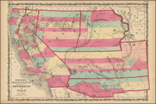
In the 19th century, the American West was rapidly changing. Not only was it a frontier of new settlements and opportunities, but it was also a canvas on which state lines and territories were being redrawn.
Following the Gadsden Purchase in 1853, which expanded the New Mexico Territory, there were immediate proposals to divide the territory, creating a separate Territory of Arizona in its southern half. These proposals, starting as early as 1856, were motivated by doubts about the capability of the territorial government in Santa Fe to effectively govern the newly-acquired southern regions.
The first such proposal emerged from a conference in Tucson on August 29, 1856, where 256 people signed a petition asking the U.S. Congress for the territory's organization. They also elected Nathan P. Cook to represent them in Congress. However, a January 1857 bill proposing the organization of the territory was rejected in the House of Representatives due to concerns about the proposed territory's insufficient population. A similar proposal was later rejected in the Senate. One contentious point was the belief that the New Mexico Territory was influenced by southern sympathizers aiming to extend slavery to the southwest.
By February 1858, the New Mexico territorial legislature passed a resolution supporting the creation of the Arizona territory. But they proposed a north–south border along the 109th meridian and suggested relocating all of New Mexico's indigenous population to northern Arizona. In April 1860, with Congress yet to decide, a convention with 31 delegates convened in Tucson, establishing a constitution for a provisional territorial government for areas south of the 34°N latitude. Dr. Lewis S. Owings was elected as the provisional governor.
Later, following the outbreak of the Civil War, Confederate States of America proposal for Arizona Territory also emerged. This proposal has been called by some the "Baylor Line," a suggested division between the territories of New Mexico and a new Arizona Territory. Proposed in 1861, the line would have divided New Mexico Territory by creating Arizona Territory from the southern part of New Mexico Territory.
The Baylor Line was named after John Robert Baylor, a Confederate officer and ardent supporter of the creation of a separate Arizona Territory. As an 18 year old in Texas, Baylor became involved in military operations against the Comanches, whicht led to a political career, with Baylor being elected to the Texas state legislature in 1851 and a US Indian agent in Jack County. His dismissal from the post saw him turn into a vocal critic of Governor Sam Houston and an advocate for stronger defense measures against the Comanche and Lipan Apache tribes.
When the Civil War broke out, Baylor's ambitions led him southwest. Commissioned as a Confederate lieutenant colonel, he pushed his forces into the New Mexico Territory. Following key victories, he audaciously proclaimed himself Governor of the newly formed Arizona Territory, which would have put the territory below New Mexico, a configuration distinct from our modern-day map. This "Baylor Line" was an audacious reimagining of the American Southwest.
However, Baylor's governance was far from smooth. A skirmish resulted in the death of Robert P. Kelly, an editor of a rival newspaper. Baylor's attitudes towards Native Americans took a darker turn, with a chilling order to exterminate the Apache tribe, revealing a more sinister side to frontier politics. This act drew the ire of the Confederate leadership, leading to Jefferson Davis stripping Baylor of his governorship and commission.
Baylor envisioned a horizontal boundary that would place Arizona below New Mexico, rather than the vertical division we recognize today. Ultimately, the Baylor Line did not come to fruition. Instead, in 1863, the Arizona Territory was established using a vertical division, placing it to the west of New Mexico. The reasons for this shift were multifaceted, including military strategies during the Civil War, economic considerations, and the evolving political landscape of the West.
Archived