|
||

|

|
|

|
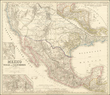
Carte des Deux Florides et de la Louisiane Inferieure, by Jean Baptiste Poirson, provides an important historical perspective of the regions spanning from present-day Texas to Florida and northwards into the southern United States. This intricate geographical representation includes territories such as Louisiana, Mississippi, Alabama, and Georgia. This artifact stands as a testament to the meticulous cartography and geographical knowledge of the early 19th century.
Poirson created this map for C. C. Robin's expeditions undertaken from 1802 to 1806. His work is remarkable for the seamless incorporation of information from diverse sources. For example, he used Jose Antonio de Evia’s Gulf Coast charts from Madrid in 1799 to portray the Gulf Coast accurately. These charts, coupled with Robin's explorations, formed the basis of the details and annotations that we see on the map.
In the region we know as Texas today, Poirson's map identifies a host of locations. These include St. Antoine de Bexar and Nacogdoches, two significant provincial cities at the time. Other notable names marked on the map are "Texas", "Taxas", "Choumans", "Nacanne", "Cenis", "Taejas", "Baie de Calveston" [i.e., Galveston Bay], and "Baie de S. Bernard".
But the map goes beyond delineating administrative divisions and geographical features; it offers substantial insights into the native populations of the time. In the region that corresponds to modern-day Alabama, Poirson identifies the territories of "Creek Superrs." and "Creek Inferrs.", providing an overview of Native American territories. Accompanying these are names of various individual villages, offering a window into the rich tapestry of Native American culture and society during the period.
Published as part of Voyages dans l'lnterieur de la Louisiane, de la Floride Occidental, et dans les Isles de la Martinique et de Saint-Domingue, pendant les annees 1802, 1803, 1804, 1805 et 1806 in 1807, this map serves as a multifaceted document. It not only traces the geographical contours of the region but also offers a socio-political narrative, linking spaces with their inhabitants and cultural histories. As such, Poirson's map provides invaluable insights into the evolution of these territories, making it a prized possession for historians, geographers, and anyone with a keen interest in understanding the making of the present through the lens of the past.

![[Texas Centennial Exposition]](https://storage.googleapis.com/raremaps/img/small/76381.jpg)
![[ Mississippi River Atlas ] Theorie der Bewegung des Wassers in Flüssen und Canälen. . . . (Atlas Volume)](https://storage.googleapis.com/raremaps/img/small/101700.jpg)