|
||

|

|
|

|
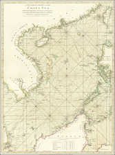
Plan of the Bay of Manilla in the Isle of Luconia, the Principal of the Philippine Islands constitutes an exceptional survey of the Manila Bay and its surrounding regions. Conducted by Señor Alexandro Malaspina and shared by Captain G.G. Richardson, this 1798 map, published by Laurie and Whittle, offers an unparalleled glimpse into the geography of the Philippines at the close of the 18th century.
As part of the Spanish Empire's ambitions to extensively map its vast colonial holdings, the expeditions led by Alexandro Malaspina, an Italian explorer in the service of the Spanish Navy, played a crucial role. In the context of these far-reaching cartographic endeavors, this chart's precise portrayal of the Manila Bay in Luzon (referred to as Luconia) - the most populous island in the Philippines - is emblematic of the era's maritime explorations and surveying advancements.
The chart showcases not only the main island of Luzon but also extends to reveal the northern coast of Mindoro, another significant island in the Philippine archipelago. Moreover, it captures several smaller islands such as Luban and offers details about other noteworthy geographic elements like Port Subic and Laguna de Tual. These intricate details, meticulously captured in the chart, underscore the depth of Malaspina's surveying efforts.
The Plan of the Bay of Manilla in the Isle of Luconia, the Principal of the Philippine Islands stands as a testament to the grand maritime expeditions of the 18th century and the cartographic strides that emerged from them. Providing an intricate depiction of Manila Bay's geography, it encapsulates a historical moment when the Spanish Empire sought to enhance its understanding of its overseas territories. As such, the chart serves not only as a navigational tool but also as an invaluable historical artifact, documenting the rich geographic knowledge of an era marked by exploration and colonialism.
Robert Laurie (ca. 1755-1836) and James Whittle (1757-1818) formed their Fleet Street, London-based firm upon the 1794 death of their employer Robert Sayer, himself one of the dominant print and mapmakers of the last half of the 18th century.
Laurie & Whittle started managing Sayer's business as early as 1787. They took over all managerial duties when Sayer's health flagged in 1792, and they changed the imprint in 1794 upon his death. Sayer left the two a 21-year lease on the shop (at £100 a year) and on Sayer's Bolt Court premises, as well as an option to acquire stock and equipment at a preferential price of £5,000 payable over three years.
Robert Laurie retired from the firm in 1812, and his role was assumed by his son, Richard Holmes Laurie (1777-1858). The younger Laurie worked with James Whittle until the latter died in 1818. After R. H. Laurie died in 1858, Alexander George Findlay, FRGS (1812-1875) purchased the firm from his daughters. The firm continues today under another name, specializing in yachting charts.
Laurie & Whittle were prolific print and map publishers, and throughout their careers, they produced numerous very important and rare works. They carried on Robert Sayer's atlas business and were responsible for editions of The Complete East-India Pilot and The American Atlas.
![[ China Sea / Luzon / Hong Kong / Canton / Formosa ] Bogt Toncqin (VOC - Dutch East India Chart by Its Chief Map Maker in Batavia)](https://storage.googleapis.com/raremaps/img/small/64690.jpg)