|
||

|

|
|

|
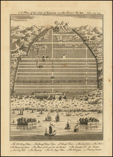
Manuscript Sea Chart of the Coasts of China, Luzon and Vietnam Drawn by the Chief Mapmaker of the Dutch East India Company in Batavia (Jakarta)
Striking and unique survival in the hand of Gerrit de Haan, the chief mapmaker of the Dutch East India Company (VOC) from 1748 to 1769, illustrating the VOC trading region between Canton, Manila and Da Nang.
This is the earliest known surviving De Haan chart of the region and an important precursor to the later chart included in De Haan's famous Dutch East India Company manuscript atlas which now resides in the Dutch National Archives at the Hague.
The chart was most likely made specifically for a VOC trading voyage to Canton in 1759, during the early period of the VOC's trading of tea and porcelain through the so-called the Canton System or single trading port system (1757-1842). In 1757, the Manchu government established Canton as the only legal port for foreign trade with China so that taxation and regulations could be enforced, and so that the government could make sure foreigners were only dealing with the Co-hong merchants, who were connected to the emperor.
The chart shows the Gulf of Tonkin and the South China Sea, including the coastlines of southern China; the islands of Hainan, Formosa [Taiwan], and Luzon [Philippines]. There are also two detailed insets. One shows Da Nang, Vietnam to Hoi An, then an important port, and Cu Lao Cham Island. The other traces the Pearl River to a fortified Canton, the only trading access the Dutch had to China from 1757 until the end of the first Opium War.
The chart is in original color. The coastlines are heightened in green, the province names and major towns in sepia, and the major islands in red. The chart also locates and includes symbols for important trading forts, beacons, batteries, flag stations, cliffs, navigational obstructions, and sandbars. Specific buildings are identified as orientation markers, for example a "Pagoodt," pagoda, on the island of Hainan. Rhumb lines radiate from an ornate compass rose. Anchors symbolize safe anchorages for VOC ships.
The chart includes notes which identify errors or omissions to be corrected. Such comments would normally be submitted to the chief chartmaker via the ship’s journal, but on occasion would be drawn directly onto the maps used by the VOC.
Drawn by Gerrit de Haan himself and bearing his trademark compass rose, this chart would have been copied from the ‘legger’ or master chart (drawn on vellum), which would have been kept in the Batavia offices of the VOC, to be duplicated as required for outgoing ships. The present example on paper would have been given to a ship's captain trading in the South China Sea, including to Taiwan and/or the Philippines, with a likely stop in the Dutch factory in Canton.
Charting Canton / Hong Kong / Pearl River Delta
The chart is noteworthy for its detailed treatment of the approach to Canton from the sea and up the Pearl River; the latter is also the subject of an inset in the upper left corner. On the larger chart, the island of Lantau is connected to a “Lantau falso.” This is one of very few charts to include the feature, marking this chart as significant. In actuality, Lantau is not connected to the rest of what is today, Hong Kong, thus the larger island shown here is a rare miscalculation on the part of Dutch hydrographers. The islands around Hong Kong had not been intensively surveyed yet despite the presence of the Portuguese there in the early sixteenth century; thirty years after this chart was made the British began to consider the island as a base of operations, decades before they expressed interest in Hong Kong.
On Lantau there is a signal station, an indication of its strategic importance to the Chinese and of the constant threat of piracy. This would correspond with the location of Fan Lau and the Tai Yu Shan Fort (later called Kai Yik Fort), completed in 1729 at the southwestern tip of Lantau Island. The fortifications were meant to defend the Pearl River estuary, the only place in China where Europeans were allowed to trade. A battery further up the river, shown on the larger chart and the inset (with a fort on the small island to the west), underlines the strategic importance of the area. A prior fort was constructed here as early as the 1660s. One popular myth provides that the fort was originally built by the Dutch, who used it as a trading place outside of Macau from which to bypass the Portuguese trading monopoly in the region.
A second signal station can be seen on the island called Taboao, immediately east of Lantao Falso. This would appear to be Tung Lung Fort, which was located on the northeastern tip of Tung Lung Chau Island. The fort was a part of the Imperial Chinese defense system against pirates which, when completed in 1724, was one of the earliest such fortifications constructed for this reason. The fort is believed to have also been a signal station, passing on messages to the military headquarters at Kowloon.
The battery shown up river (also shown with a fort opposite it in the Pearl River inset), is likely Chiwan Battery, near modern Shenzhen, which was constructed in 1717. There were actually two Chiwan Batteries built and the fort may be the second of the two batteries.
For a more complete overview of the Imperial Chinese Forts near Hong Kong, visit Gwuolo Old Hong Kong: https://gwulo.com/taxonomy/term/2154
In the Pearl River Delta Inset, there are many other features of interest. A credible town plan of Canton is given, including the internal walls and primary government buildings in the interior, as well as the trading area for foreigners to the south of the river and the two forts on the hill overlooking the city. A beacon is shown in the middle of the river southeast of the city, with another beacon further south on the west side of the river and a third beacon on a hill to the east across the river. At the mouth of the Pearl River an anchorage below the fort and battery likely represents the point where foreign vessels were expected to remain before entering the river.
Mapping the Philippines
The De Haan chart includes detailed coverage of the west coast of Luzon, Philippines, as well as three large shoals off the coast. Most of the information seen here derives from the famous Velarde-Bagay Map of 1734, or from a shared VOC manuscript source.
Coming twenty-five years after the Murillo Velarde map, the De Haan chart introduces additional symbolic bathymetric data, rendering coastal reefs in greater detail and the blue water shoals with more specificity. Two anchorages are shown, one near present-day Laoag City and the other on the inside of the Balinao Peninsula. The Velarde Map notes an anchorage in the vicinity of the latter, but it does not show the former. On the De Haan chart Manilla is noted as "Baaij manielha".
Here the Abulog River is shown extending from coast to coast at the north of Luzon. On the De Haan, the Cagayan River has the characteristic inland zigzag of the Murillo Velarde map.
Three western shoals are shown on the De Haan chart. From north to south the shoals are labeled: "B: de bulinao" ("Galit" on the Velarde Map), "B. mar Singula" ("Panacot" on the Velarde Map) and the third is unnamed ("Lumbay" on the Velarde Map). The name of Scarborough Shoal as "B[anco] mar Singula" is intriguing – this is among the earlier mentions of the Scarborough Shoal with this name. It is likewise referred to as "Marsingola" or "Mar singola" in other historical sources.
The chart also shows the Pratas Reef, Macclesfield Bank, and the Paracels.
The Dutch and the VOC in Southeast Asia
The first fleet of Dutch ships to arrive in the East Indies sailed from the Netherlands in 1595; Cornelis de Houtman and Gerrit van Beuningen commanded the expedition. It was funded by one of the forerunner companies of the larger VOC, known as the voorcompagnieën, or precursor companies. The Dutch knew that the Portuguese already had a strong trading presence around the Malay Archipelago, thus the fleet steered for Java, where the Portuguese had not managed to plant commercial outposts.
After a difficult voyage, the fleet arrived in the Bay of Banten in June 1596. However, it was difficult to establish a commercial relationship with the leaders there, leading the Dutch to search for a more hospitable port. Although it had no desirable trading goods at the time, the First Fleet did visit Jakarta before returning to Amsterdam in August 1597.
While this first voyage did not result in great wealth, it did cover the cost of its investors and lit a fire under Dutch merchants eager to trade with the East Indies. 22 ships sailed in 1598, part of five fleets. From 1599 to 1601, an average of thirteen ships made the journey to seek spices and goods. In 1602, the trade was put under the complete control of the Vereenigde Nederlandsche Geoctroyeende Oest-Indische Compagnie, or VOC. Its Board of Directors, the Heren Zeventien or Gentlemen Seventeen, ruled over Company decisions.
One of these decisions was to move the Company’s trade headquarters from Banten, where they encountered considerable difficulties, to the less-populated vassal state of Jakarta in 1618. The VOC built a walled city at Jakarta, transforming the city into a major trade center over the next two centuries. While they did clash with local peoples, namely those of Bantan and Mataram, as well as the English, Dutch influence in the region grew considerably following the establishment of Jakarta as their main factory.
Their influence beyond the archipelagoes that today form Indonesia and to a certain extent Malaysia, however, was less pronounced. In some cases, this was intentional, as was the case with Cambodia and Vietnam. In others, it was because they had no choice but to be peripheral actors, as with China and Japan. Breaking into the Chinese trade, one of the largest in the world even then, was always a major goal of the VOC, and relations in the South China Sea were a constant project for the Company.
The VOC did briefly control Taiwan—or Formosa as it was then called, a name the Portuguese had given the island—in the mid-seventeenth century, but the Chinese forced them out in 1668. Afterward, the Dutch traded with China at Fuzhou (1662-1681) and later Canton (1728-1830). The latter is emphasized on this map with an inset. The Dutch had a permanent factory on the waterfront of Canton, next to their competitors, the British. The Dutch also traded a considerable amount with the Philippines, but those islands were under Spanish colonial rule.
By the time this chart was drawn, the VOC acted more as a regional ruling power than as a “flexible commercial organization,” as Gommans and Van Diessen explain (vol. vii, 33). It had a trading presence and intense interest in the region shown here, hence the need for a chart of the area, but it had few mainland factories and instead depended on Chinese and Japanese middlemen and diaspora merchants to aid in its trade with the lucrative economies of China and Japan.
Cartography in the VOC and Gerrit de Haan
One of the secrets to the VOC’s success, and it certainly was kept a secret, was their tight control of geographic knowledge about the Indies route and the hydrography of the waters of Southeast Asia. A reason they chose Jakarta as their headquarters was the relative amount of information company ships had gathered about its surrounding waters, information they sought to keep in-house and not share with rival commercial entities and empires.
The VOC contained two sets of cartographic workshops and archives, one in Amsterdam and, from the second half of the seventeenth century, one in Batavia. The Amsterdam site had appointed hydrographers, including Hessel Gerritsz and the Blaeu family, who were trusted with making charts of East Indies waters. This information was initially supposed to be kept secret, but it often leaked out in the publicly available charts sold by these cartographers at their Amsterdam shops.
By the eighteenth-century, when this chart was made, secrecy was less of a priority, as most of the Southeast Asian waters were tread by several European powers. The VOC also employed cartographers to continually update and refine their charts. Gerrit de Haan was one of these employees. He served as the baaskaartenmaker, or chief chartmaker, of the Batavia factory from 1748 to 1769.
His job also included processing information brought back from exploratory expeditions. The most famous of these were the two voyages of Abel Tasman in the early 1640s, wherein Tasman was the first European to encounter New Zealand, but there were dozens of such reconnaissance voyages throughout the seventeenth and eighteenth centuries.
This chart was likely created by De Haan for a vessel charged on a trading voyage in the South China Sea. Shorter trips allowed for paper charts, whereas longer voyages often needed sturdier vellum charts. This chart, with annotations highlighting missing information and further tips for navigation, was a precursor to a chart that later featured in De Haan’s Ligtende zeefakel, although that chart would have an additional inset, making this example unique.
Extra Annotations
The note at the top center appears to say, “Mijn sea versand ook in ? kaart grote va(n) formate t’eyland Botte ander Ylands te verboten ? moet rederen.” This note refers to the inset in the upper left corner. Although in need of further research, it very roughly translates to, “The sea and river mouth has sand banks, as also shown in the map of large format, at the blunt island and other islands (your cargo) may or must have to be transferred to smaller boats and you have to anchor.”
The second note appears to be a navigational note, “Hier moet mandorgaans kap zien in de koers ook zal veel nord by ? (oost).” Again, a very rough translation is, “Here must you normally see the cape in a course of north by east.”
On the verso, the map is inscribed "1759 Verbeterde, Kaart van de Pracelles tot Canton,” which translates as, “1759 Improved Map of the Pracelles [Paracels} to Canton.”
Rarity and comparison to the Nationaal Archief Version
All charts by Gerrit de Haan are rare. This chart is known in only one other example, held at the Nationaal Archief in The Hague. That chart extends farther to the south and east. It also has a different shape to several features, for example to the southern tip of Taiwan and to the Pratas Islands.
The later chart, dated 1760, also contains three insets, not two as in this example. Additionally, the content of the insets is different. Whereas both charts contain the Canton and Pearl River inset and the Cu Lao Cham Island inset, the later example at the Nationaal Archief also contains a third inset showing the Paracel Islands in more detail. Interestingly, the Paracels on both charts are shown as surrounded by shallows, a mistake copied in many VOC charts; in reality, the sea is very deep around the islands.
This is the only known example to have two insets. As it was most likely made for a South China Sea voyage and is on paper, it is an extremely rare survival.
Provenance:
The map was included in an auction at Christie’s Swire, Hong Kong, on September 26, 1989, lot 1070.
Gerrit de Haan was the chief mapmaker (baaskaartenmaker) of the VOC (the Dutch East India Company) in Batavia, the VOC trading center in Asia, from 1748 to 1769.
In the second half of the seventeenth century, a mapmaking workshop (kaartenmakerswinkel) was opened in Batavia under the supervision of a chief mapmaker who was responsible for supplying charts to ships returning to the home country or sailing to various trading posts of the Company.
As the VOC's chief mapmaker, De Haan compiled a two-volume manuscript atlas Ligtende zeefakkel off de geheele Oost-Indische Waterweerelt (Blazing Beacon or the Whole of the East India Sea World), which included charts of the coasts and waters between the Cape of Good Hope and Japan, in the years 1760-1761. The first volume of this atlas was completed in 1760 and contains the part of the VOC charter area lying to the east of Sunda Strait. The second volume covers the areas of land and sea between the Cape of Good Hope and the west coast of Sumatra, plus the west coast of Australia and the coasts of Java. It was concluded in February 1761. The atlas is partly based on the surveys and charts by earlier map-makers, like Joan Blaeu (1596-1673) and Victor Victorsz.
![Belgium Foederatum auctius et emendatius… [Large inset of SE Asia]](https://storage.googleapis.com/raremaps/img/small/89316.jpg)