|
||

|

|
|

|
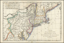
Nice example of the best atlas map of New York State published in the 19th century, with the imprint line crediting the partnership of Tanner, Vallance, Kearny & Co.
This vividly colored example is richly annotated throughout the map with various regional details on various rivers, roads, and other local features.
The early counties are shown in remarkable detail, from original surveys. Includes roads, rivers, lakes, turnpikes, villages, mills, ironworks, forts, post offices, battle grounds, places of worship, public houses, roads, ferries, falls, etc.
Tanner commenced production of his most ambitious project, his American Atlas, in 1818. Released in 5 folios between 1819 and 1823, the Atlas is widely regarded as the single most beautiful large-scale American atlas ever published. The maps are large, detailed and elegantly engraved. The production resulted in the split of Tanner from his partners Kearney & Vallance, but resulted in the greatest of American Atlases.
The present example of the map is updated to 1825.
![[ Battle of Saratoga ] Plan of the Position which the Army under Lt. Gen. Burgoine took at Saratoga on the 10th of September 1777 and in which it remained till the Convention was signed.](https://storage.googleapis.com/raremaps/img/small/101239.jpg)