|
||

|

|
|

|
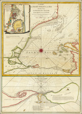
A Chart of the Mouths of Hoogly River and of the Roads of Balasore and Piply, based on the diligent surveys conducted by John Ritchie and Benjamin Lacam, offers a meticulous depiction of the riverine geography in the region of present-day West Bengal and Odisha in India. The chart, engraved by William Palmer and published by Laurie & Whittle in May 1794, stands as an invaluable testimony to the cartographic practices in the service of the East India Company during the late 18th century.
The chart itself is remarkable for its detailing of the Hoogly River from Point Palmiras to Lacam's Channel, extending to the town of Hoogly. Executed under the patronage of the East India Company, the map epitomizes the precision with which marine surveying was conducted during the period. The painstaking notation of features such as high tide timings, direction of the strongest flood-tides, and the depth of the river at low tide reflects an emphasis on nautical accuracy vital for navigation and commerce.
Benjamin Lacam's role in the creation of the chart goes beyond his surveys of the river. A particular highlight is an inset in the upper left corner of the chart that provides a detailed portrayal of a section of the Hoogly River, known as the Calcutta River, between Barnagur and Tanna Fort. This detailed inset includes all soundings and moorings and features a particular plan of Fort William, underscoring Lacam's commitment to detail and precision in his work.
The chart provides important insights into the materiality of the river and its environs. The notations that the sands are hard ground, the channels are soft ground, and the Hoogly River and Lacam's Channel are depicted as soft blue ground, convey a keen understanding of the river's physical properties. This reflects the vital role such details played in navigation and commercial operations, further accentuating the map's historical significance.
This cartographic document is a reflection not only of geographical knowledge but also of the institutional structures that supported its creation. The dedication to the Lords Commissioners of the Admiralty underscores the chart's connection to the highest echelons of British naval administration. As such, it stands as a testament to the close-knit relationship between cartography, naval enterprise, and colonial administration during this era.
Furthermore, the chart offers a window into the operations of the Honorable East India Company. John Ritchie, one of the primary surveyors, held the position of marine surveyor to the East India Company, indicating the company's substantial investment in accurate maritime knowledge. In the context of the Company's increasing control over vast territories in India during the late 18th century, such charts played a crucial role in facilitating trade and navigation.
Lastly, the chart, engraved by William Palmer and published by Laurie & Whittle, is an embodiment of the craft of cartography during the late 18th century. The intricate details, along with the technical notations, encapsulate the sophisticated engraving techniques and printing practices of the time. The chart serves not only as a historical document of geographic and maritime interest but also as a notable artifact of the art of cartography during a significant period of British colonial history.
Robert Laurie (ca. 1755-1836) and James Whittle (1757-1818) formed their Fleet Street, London-based firm upon the 1794 death of their employer Robert Sayer, himself one of the dominant print and mapmakers of the last half of the 18th century.
Laurie & Whittle started managing Sayer's business as early as 1787. They took over all managerial duties when Sayer's health flagged in 1792, and they changed the imprint in 1794 upon his death. Sayer left the two a 21-year lease on the shop (at £100 a year) and on Sayer's Bolt Court premises, as well as an option to acquire stock and equipment at a preferential price of £5,000 payable over three years.
Robert Laurie retired from the firm in 1812, and his role was assumed by his son, Richard Holmes Laurie (1777-1858). The younger Laurie worked with James Whittle until the latter died in 1818. After R. H. Laurie died in 1858, Alexander George Findlay, FRGS (1812-1875) purchased the firm from his daughters. The firm continues today under another name, specializing in yachting charts.
Laurie & Whittle were prolific print and map publishers, and throughout their careers, they produced numerous very important and rare works. They carried on Robert Sayer's atlas business and were responsible for editions of The Complete East-India Pilot and The American Atlas.
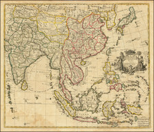
![Tabula Asiae XI [India and Southeast Asia]](https://storage.googleapis.com/raremaps/img/small/94323.jpg)