


|
||

|

|
|

|
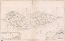
Shows the Results of Several Surveys Around North Sentinel Island.
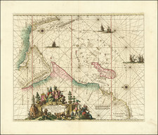
Chart of the Andaman and Nicobar Islands, published on 12th July 1799 by Laurie & Whittle of London, provides a detailed visual representation of the Andaman and Nicobar archipelagos. Compiled from the observations of Captains Phineas Hunt, Mackay, John Ritchie, Lieutenant McCluer, and others, this chart offers essential data on the geography and topography of the islands at the end of the 18th century.
During the late 18th century, maritime exploration was advancing, with European powers keenly charting unknown territories. Situated at the juncture of the Bay of Bengal and the Andaman Sea, the Andaman and Nicobar Islands held strategic significance. Charts such as this one were vital for navigation and the establishment of potential trade routes.
The chart's insets provide a more detailed view of particular regions of interest. One notable inset shows "The Channel Between The Great and Little Andaman Islands," marking the passage of the Ganges under Captain Duncan's command in 1759 and 1760. Additional insets depict "Port Cornwallis," "The Harbour of Carmorta or Noncowry," and the bifurcation of "Great Andaman" into its northern and southern segments.
Further enriching the chart are the remarks by Captain Phineas Hunt regarding the Nicobar Islands. His comments provide tangible information about Carmorta's vegetation, its water sources, and other geographical characteristics. He also offers insights into the living conditions, resources, and the nature of the archipelago's inhabitants. Hunt's detailed observations, such as the description of the landscape, potential port sites, and the islands' resources, contribute to a comprehensive understanding of the region.
North Sentinel Island, located west of the southern part of South Andaman, was, and remains, home to the Sentinelese, an indigenous people who have consistently resisted contact with the outside world. Their determined isolation made the island a challenging subject for maritime explorers and cartographers of the era. By the 18th century, although European powers were expanding their horizons, North Sentinel Island stood as a poignant reminder of the limits of colonial reach, its shores safeguarding the autonomy and enigma of its inhabitants.
Robert Laurie (ca. 1755-1836) and James Whittle (1757-1818) formed their Fleet Street, London-based firm upon the 1794 death of their employer Robert Sayer, himself one of the dominant print and mapmakers of the last half of the 18th century.
Laurie & Whittle started managing Sayer's business as early as 1787. They took over all managerial duties when Sayer's health flagged in 1792, and they changed the imprint in 1794 upon his death. Sayer left the two a 21-year lease on the shop (at £100 a year) and on Sayer's Bolt Court premises, as well as an option to acquire stock and equipment at a preferential price of £5,000 payable over three years.
Robert Laurie retired from the firm in 1812, and his role was assumed by his son, Richard Holmes Laurie (1777-1858). The younger Laurie worked with James Whittle until the latter died in 1818. After R. H. Laurie died in 1858, Alexander George Findlay, FRGS (1812-1875) purchased the firm from his daughters. The firm continues today under another name, specializing in yachting charts.
Laurie & Whittle were prolific print and map publishers, and throughout their careers, they produced numerous very important and rare works. They carried on Robert Sayer's atlas business and were responsible for editions of The Complete East-India Pilot and The American Atlas.
![Carte Particuliere d'une Partie d'Asie ou sont Les Isles D'Andemaon, Ceylan, Les Maldives . . . [with] Partie Occidentale d'une D'Asie ou sont les Isles De Zocotora De l'Amirante . . .](https://storage.googleapis.com/raremaps/img/small/99858.jpg)
![(First state!) [ Southeast Asia ] Tabula Asiae XI](https://storage.googleapis.com/raremaps/img/small/94616.jpg)