|
||

|

|
|

|
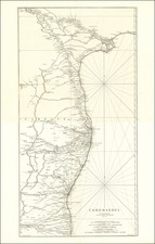
A Geohydrographic Draught of the Northern Circars is a meticulously prepared chart of the maritime provinces on the coasts of Golconda and Orissa. Published in London on May 12, 1794, by Laurie & Whittle, this chart was the culmination of the most comprehensive surveys of those parts that were available at the time. The craftsmanship of S.J. Neele, who engraved this chart, is evident in its intricate details and precision.
Significantly, the chart includes two inset plans. The first presents the fort of Bimilipatnam, which was taken from the Dutch in July 1781 and then later restored as part of a peace agreement. The rendering of the fort gives a sense of its strategic position and layout, a crucial element of military interest for the period.
The second inset plan provides a detailed layout of the town and harbor of Vizagapatnam. This urban and maritime representation underscores the town's strategic and commercial significance along the coast, as Vizagapatnam was a crucial hub for naval and trade activities.
The chart includes seven coastal profiles that provide views of the coast's appearance from the sea, offering a mariner's perspective of the landscape. These profiles would have been invaluable for sailors in recognizing landmarks and navigating the coastal waters safely and efficiently.
What sets this chart apart from many others produced by Laurie & Whittle is the considerable attention paid to topography. The inland features, elevations, and terrain variations are detailed with particular care, indicating not just a maritime interest, but also a comprehensive geographical overview of the region. This attention to inland detail may reflect a broader colonial interest in the region's governance, land use, and resource potential.
This geohydrographic chart encapsulates an intersection of interests - maritime navigation, military strategy, and colonial administration. Its creation reflects the utilitarian needs of the British Empire in the late 18th century, including navigation, defense, and territorial management.
Furthermore, the chart stands as a testament to the era's cartographic practices, where scientific precision, careful observation, and skilled craftsmanship combine. The meticulous engraving by S.J. Neele, combined with the information gathered from comprehensive surveys, resulted in a map that is not only practical but also a significant piece of art and historical record.
In a broader context, the chart provides a glimpse into the geographic knowledge and territorial interests of the British Empire in the late 18th century. It is a reflection of the era's technological capabilities, scientific curiosity, and imperial expansion. Its very existence reveals a moment in history when the coasts of Golconda and Orissa were of particular strategic and commercial interest to Britain.
Lastly, this chart serves as a valuable primary source for historians and geographers. It offers a detailed, accurate representation of the Northern Circars in the late 18th century, providing insights into the region's geographical features, settlements, and maritime landmarks at the time.
Robert Laurie (ca. 1755-1836) and James Whittle (1757-1818) formed their Fleet Street, London-based firm upon the 1794 death of their employer Robert Sayer, himself one of the dominant print and mapmakers of the last half of the 18th century.
Laurie & Whittle started managing Sayer's business as early as 1787. They took over all managerial duties when Sayer's health flagged in 1792, and they changed the imprint in 1794 upon his death. Sayer left the two a 21-year lease on the shop (at £100 a year) and on Sayer's Bolt Court premises, as well as an option to acquire stock and equipment at a preferential price of £5,000 payable over three years.
Robert Laurie retired from the firm in 1812, and his role was assumed by his son, Richard Holmes Laurie (1777-1858). The younger Laurie worked with James Whittle until the latter died in 1818. After R. H. Laurie died in 1858, Alexander George Findlay, FRGS (1812-1875) purchased the firm from his daughters. The firm continues today under another name, specializing in yachting charts.
Laurie & Whittle were prolific print and map publishers, and throughout their careers, they produced numerous very important and rare works. They carried on Robert Sayer's atlas business and were responsible for editions of The Complete East-India Pilot and The American Atlas.
![An Account of the Kingdom of Caubul, and its Dependencies in Persia, Tartary, and India; Comprising a View of the Afghaun Nation, and a History of the Dooraunee Monarchy [with map:] A Map of the Kingdom of Caubul, and some of the Neighbouring Countries](https://storage.googleapis.com/raremaps/img/small/89552.jpg)
![Northern Hindostan [with] Nepaul [with] Cabul](https://storage.googleapis.com/raremaps/img/small/62805.jpg)