|
||

|

|
|

|
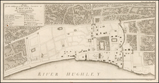
Rare Plan of Calcutta (now Kolkata, India) Follow of East India Company Rule
Hand colored version of this very large and detailed plan, first issued shortly after the end of the East India Company's control of Kolkata.
The plan is extensively detailed, offering a minute view of the growing city. Through the growth and changes the city underwent, Fort William, Calcutta’s citadel, remained prominent and striking, as seen on this plan. It was constructed in 1690 and named for King William III of England; it became the primary Bengal trading station of the East India Company. It was reconstructed in 1773 as it stands in this plan.
The first edition of the map shows the extent of the city of Kolkata up to the year 1877. The Hooghly River cuts through the left side of the map, with much of the city to its east.
It includes a scale represented graphically and in ratio form (6 inches = 1 mile). The left side of the map includes 3 tables, referencing a numbered list of hundreds of streets in Calcutta (one alphabetical and one numeric). At the bottom left, there is a small legend with symbology for map features including town boundaries, metalled roads, unmetalled roads, hauts/bazaars, police stations, public buildings, and burial grounds.
A comparison to the final map produced during the East India Company Rule in 1874 illustrates the rapid growth in this period. While the scales are identical, this map is nearly double the size of the East India Company's map. https://www.raremaps.com/gallery/detail/58589
The map includes a text paragraph below the title, noting the sources of the map, including:
- Simm's Plan of Calcutta (1877)
- Captain W.J. Stewart's Survey (1868-70)
- Major R. Smith's Survey (1849-50)
- Mr. N.T. Davey's Survey (1871-72)
States of the Map & Rarity
The map is extremely rare. There appear to be 3 states of the map:
- September 1877
- Corrected up to January 1878
- Additions in 1882
OCLC locates 1 example of the 1882 edition (University of Oxford). We OCLC locates 3 examples of the 1877 state of the map (British Library, University of Minnesota, University of Oxford) and 1 example of the 1878 (University of Melbourne).
We note a single example at auction (this example) and no examples in dealer catalogs listed by AMPR.