|
||

|

|
|

|
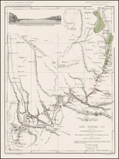
Rare large-format British sea chart of Hainan's south coast, centered on Sanya and Yalong Bay, first published in the 1781 by Sayer & Bennett, and here re-issued by their successors, Laurie & Whittle, in 1794.
Based upon John Haldane's 1776-7 survey of the region, commissioned by the British East India Company, the chart appeared in several editions of the 'The East-India Pilot, or Oriental Navigator',
The chart prominently captures key landmarks: from the western 'Guichou' fort in the Yazhou area, to 'Samouy' (modern Sanya), 'Galloon Bay' (now known as Yalong Bay with its opulent resorts), to the forts at 'Tonckeu' and 'Tongsoy', and further to 'Linksuey' (Lingshui) and the island 'Tinhosa' (Dazhou Island). Detailed maritime notations, such as bathymetric soundings and potential hazards, embellish the map.
The chart has a fascinating genesis. Historically, European ships briefly stopped at Hainan's coast en route to Canton, yet no thorough mapping efforts were undertaken. In 1776, the HMS Earl of Sandwich, led by Captain Charles Deane of the British East India Company, anchored at Yalong Bay due to unfavorable seasonal sailing conditions. During this extended stay, the ship's Master, John Haldane, undertook the pioneering survey of Hainan's southern coast. While not scientifically exhaustive, his survey substantially elevated European understanding of the area.
States
The map was first issued in by Sayer and Bennett, and then in 1794 by Laurie & Whittle.
Robert Laurie (ca. 1755-1836) and James Whittle (1757-1818) formed their Fleet Street, London-based firm upon the 1794 death of their employer Robert Sayer, himself one of the dominant print and mapmakers of the last half of the 18th century.
Laurie & Whittle started managing Sayer's business as early as 1787. They took over all managerial duties when Sayer's health flagged in 1792, and they changed the imprint in 1794 upon his death. Sayer left the two a 21-year lease on the shop (at £100 a year) and on Sayer's Bolt Court premises, as well as an option to acquire stock and equipment at a preferential price of £5,000 payable over three years.
Robert Laurie retired from the firm in 1812, and his role was assumed by his son, Richard Holmes Laurie (1777-1858). The younger Laurie worked with James Whittle until the latter died in 1818. After R. H. Laurie died in 1858, Alexander George Findlay, FRGS (1812-1875) purchased the firm from his daughters. The firm continues today under another name, specializing in yachting charts.
Laurie & Whittle were prolific print and map publishers, and throughout their careers, they produced numerous very important and rare works. They carried on Robert Sayer's atlas business and were responsible for editions of The Complete East-India Pilot and The American Atlas.

![[Macau] Plan de la Ville et du Port de Macao](https://storage.googleapis.com/raremaps/img/small/74702.jpg)