


|
||

|

|
|

|
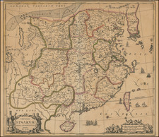
Detailed map of a portion of Chinese Tartary by the French cartographer Jean Baptiste Bourguignon d'Anville.
One of the most interesting aspects of the map is its depiction of the Tcitcicar, Merguen and Tagouri regions, which were little-known and poorly understood by Europeans at the time. The map shows these regions as being located in the eastern part of Chinese Tartary, near the border with Siberia. The Tcitcicar region is shown as being a relatively small area, bounded by the Erg un-Kerrein Mountains to the north and the Desert of Gobi to the south. The Merguen region is depicted as being slightly larger, and is located to the north of the Tcitcicar region. Finally, the Tagouri region is shown as being the largest of the three, and is located to the east of the eerguen region, near the border with Siberia.
In addition to its geographical information, the map also includes a wealth of cultural and political information about the region. For example, the map shows the locations of roads, various cities and towns, and the names of various tribes and ethnic groups that lived in the region
Jean-Baptiste Bourguignon d’Anville (1697-1782) was one of the foremost French geographers of the eighteenth century. He carried out rigorous research in order to create his maps, which greatly developed the technical proficiency of mapmaking during his lifetime. His style was also simpler and less ornate than that of many of his predecessors. It was widely adopted by his contemporaries and successors.
The son of a tailor, d’Anville showed cartographic prowess from a young age; his first map, of Ancient Greece, was published when he was only fifteen years old. By twenty-two, he was appointed as one of the King’s géographes ordinaire de roi. He tutored the young Louis XV while in the service to the Crown. However, royal appointment did not pay all the bills, so d’Anville also did some work for the Portuguese Crown from 1724. For example, he helped to fill out Dom João V’s library with geographical works and made maps showing Portugal’s African colonies.
D’Anville disapproved of merely copying features from other maps, preferring instead to return to the texts upon which those maps were based to make his own depictions. This led him to embrace blank spaces for unknown areas and to reject names which were not supported by other sources. He also amassed a large personal map library and created a network of sources that included Jesuits in China and savants in Brazil. D’Anville’s historical approach to cartography resulted in magnificently detailed, yet modern and academic, maps. For example, his 1743 map of Italy improved upon all previous maps and included a memoir laying out his research and innovations. The geographer also specialized in ancient historical geography.
In 1773, d’Anville was named premier géographe de roi. In 1780, he ceded his considerable library to the Ministry of Foreign Affairs to be used for as a reference library for diplomats. D’Anville is best known for several maps, including his map of China, first published in 1735, and then included with Du Halde’s history of that country (the Hague, 1737). His map of Africa (1749) was used well into the nineteenth century.
![The New Map and Street Directory of Shanghai City. Новый план города Шанхая с указателем улиц [Cover title] / The New Map and Street Directory of Shanghai City 最近實測上海地圖 [Zui jin shi ce Shanghai di tu]](https://storage.googleapis.com/raremaps/img/small/93141.jpg)
![The Turkish Empire in Asia [shows Cyprus]](https://storage.googleapis.com/raremaps/img/small/37050.jpg)
![[ Guangzhou / Canton ] Map of the City and Entire Suburbs of Canton. Made By Rev. D. Vrooman. 1855.](https://storage.googleapis.com/raremaps/img/small/62631.jpg)